TerraPulse · research papers

Open data, open notes.

Active research in environmental data science — seismology, space weather, climate, hydrology, and the cross-domain bits where everything starts to look the same. All studies built on open government data.

74
Studies
8
References
7
Domains
Seismologypublished
May 2026

UFO Reports Don't Cluster Around US Earthquakes — 104-Year NUFORC × USGS Cross-Match

Population-level test of the earthquake-lights folklore: 9,379 US M>=4.5 earthquakes (1910-2014) cross-matched against 71,008 NUFORC reports. Observed coincidences (3) sit below the 10,000-permutation null mean (9.4); null survives every sensitivity check.

9 data files
Researchactive
May 2026

The Truth about Skinwalker Ranch — Phase 1 Baseline

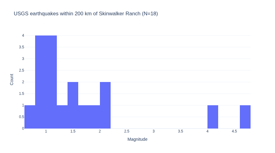
Local baseline characterization of the geographic environment at Skinwalker Ranch (40.2549°N, -109.8864°W). Phase 1 of GitHub issue #222.

Visualization for The Truth about Skinwalker Ranch — Phase 1 Baseline
Interactive viz 11 data files
Cross-Domainpublished
May 2026

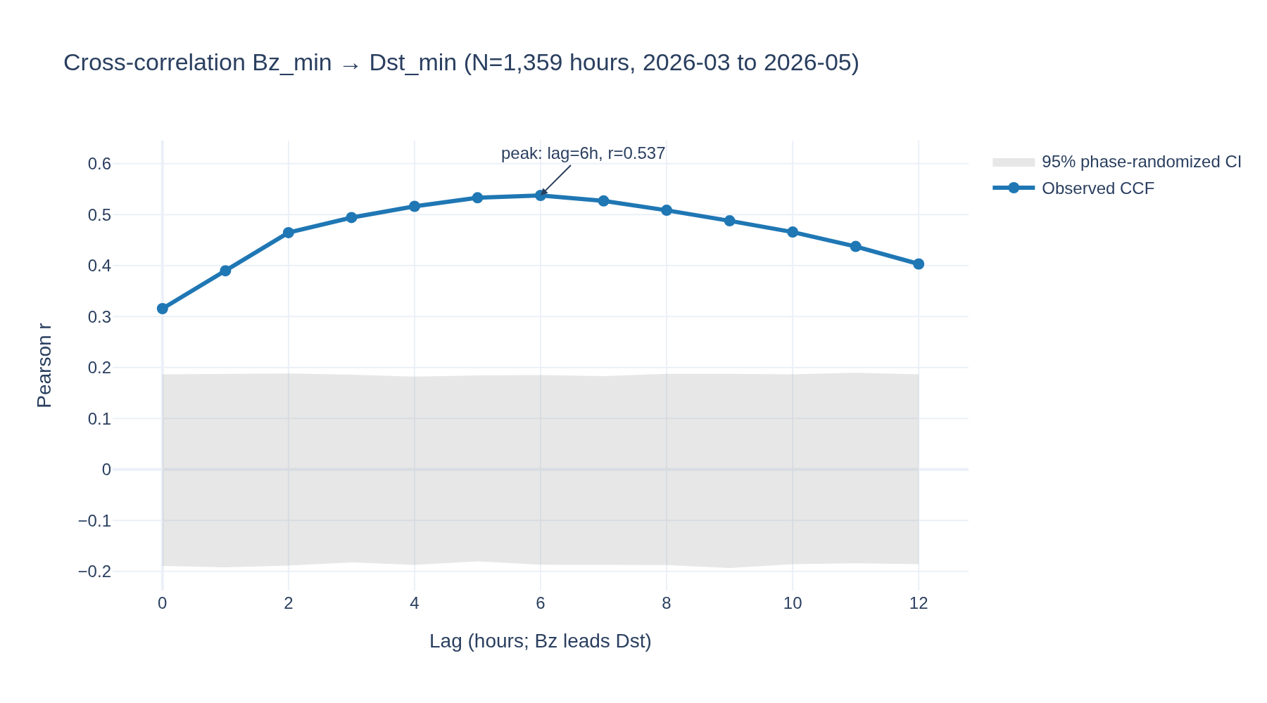
Bz → Dst predictive lead-time — Granger causality on solar-wind driver vs ring-current response

How many hours does southward IMF Bz lead Dst-index minima, and is the predictive relationship Granger-causal? Pure space-weather predictability test on TerraPulse's 71-day Bz/Dst overlap window.

Visualization for Bz → Dst predictive lead-time — Granger causality on solar-wind driver vs ring-current response
Interactive viz 3 data files
Space Weatheraccepted
May 2026

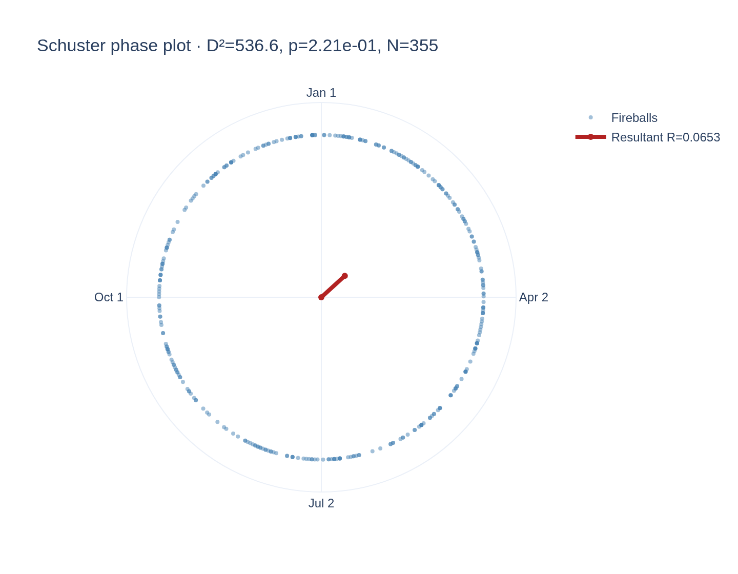
PMA: CNEOS fireball day-of-year vs. meteor-shower calendar (1998-2026)

CNEOS fireball day-of-year tested against 12 named meteor shower peaks. Clean null after deduplication: Schuster p=0.22, zero showers survive Bonferroni at any window width. Detection floor at N=355 is rate ratio >=1.96 (Bonferroni-12); optical-bolide Geminid ratios of 1.3-1.5 are below the floor.

Visualization for PMA: CNEOS fireball day-of-year vs. meteor-shower calendar (1998-2026)
Interactive viz 2 data files
Researchcomplete
May 2026

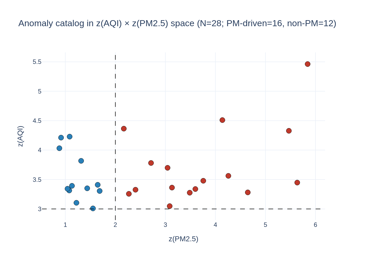
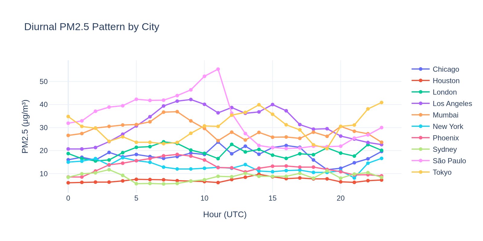
AQI Anomaly Characterization Across 10 Global Cities

Cluster >3sigma AQI anomaly days across 10 cities by their constituent-pollutant signatures (PM2.5, PM10, O3, NO2, SO2, CO).

Visualization for AQI Anomaly Characterization Across 10 Global Cities
Interactive viz 4 data files
Space Weathercomplete
May 2026

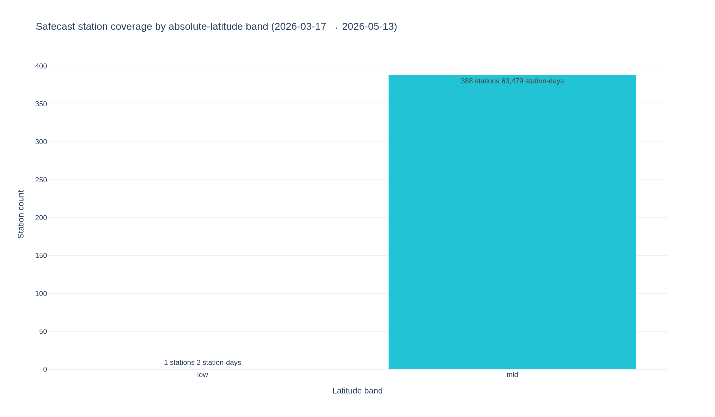
Safecast background radiation vs solar Forbush decreases — V2 of /articles/solar-watch-april-2026

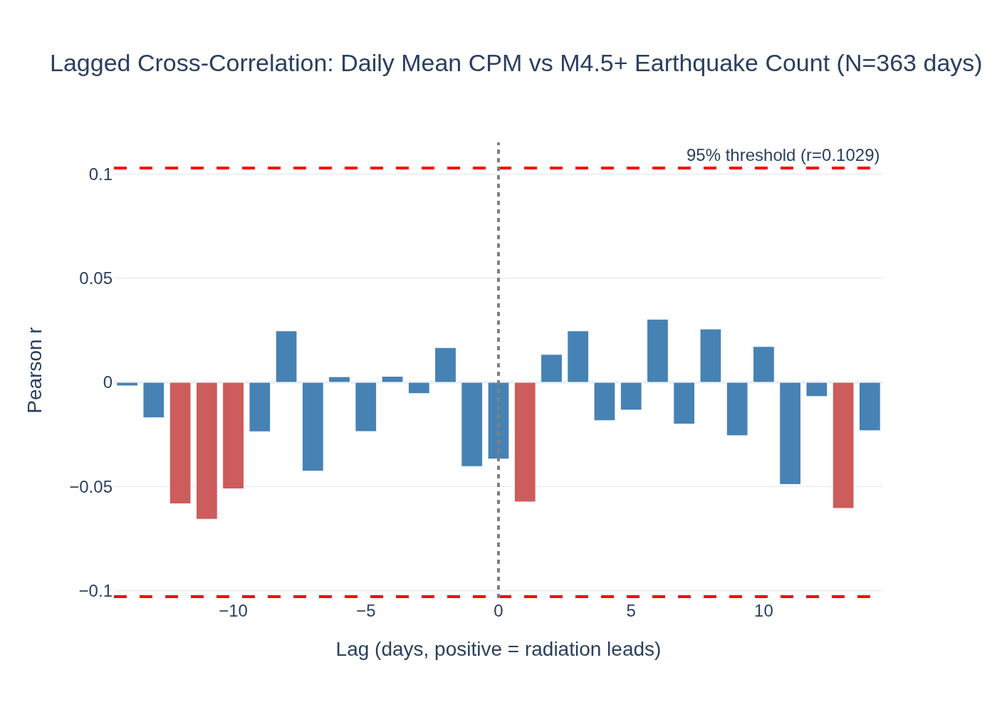
Do ground-level Safecast background-radiation measurements show a measurable depression during Forbush decreases (galactic-cosmic-ray flux reductions following CME shock arrivals)?

Visualization for Safecast background radiation vs solar Forbush decreases — V2 of /articles/solar-watch-april-2026
Interactive viz 4 data files
Space Weathercomplete
May 2026

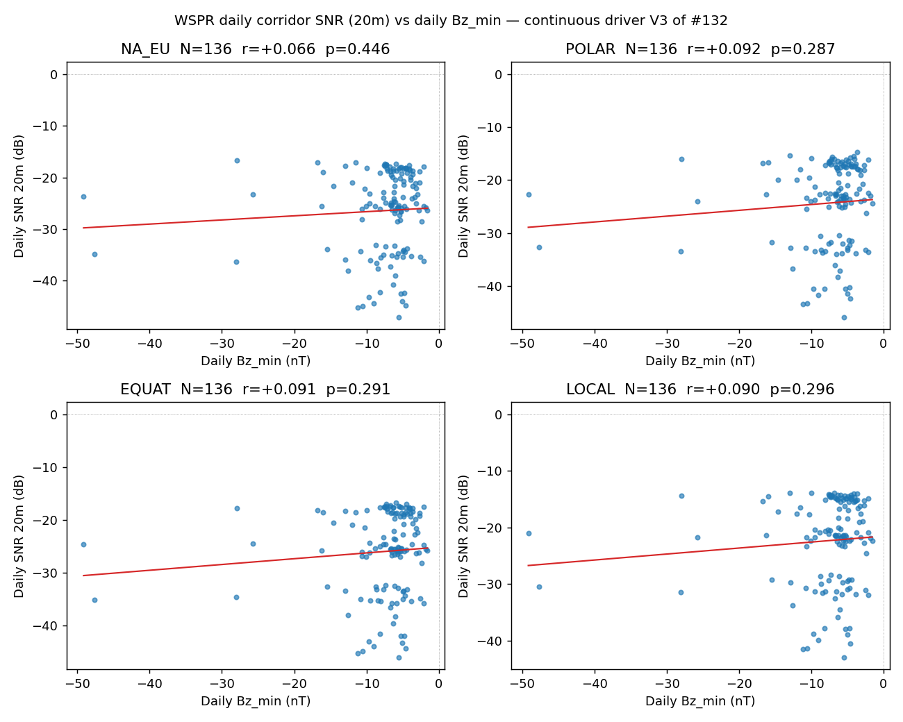
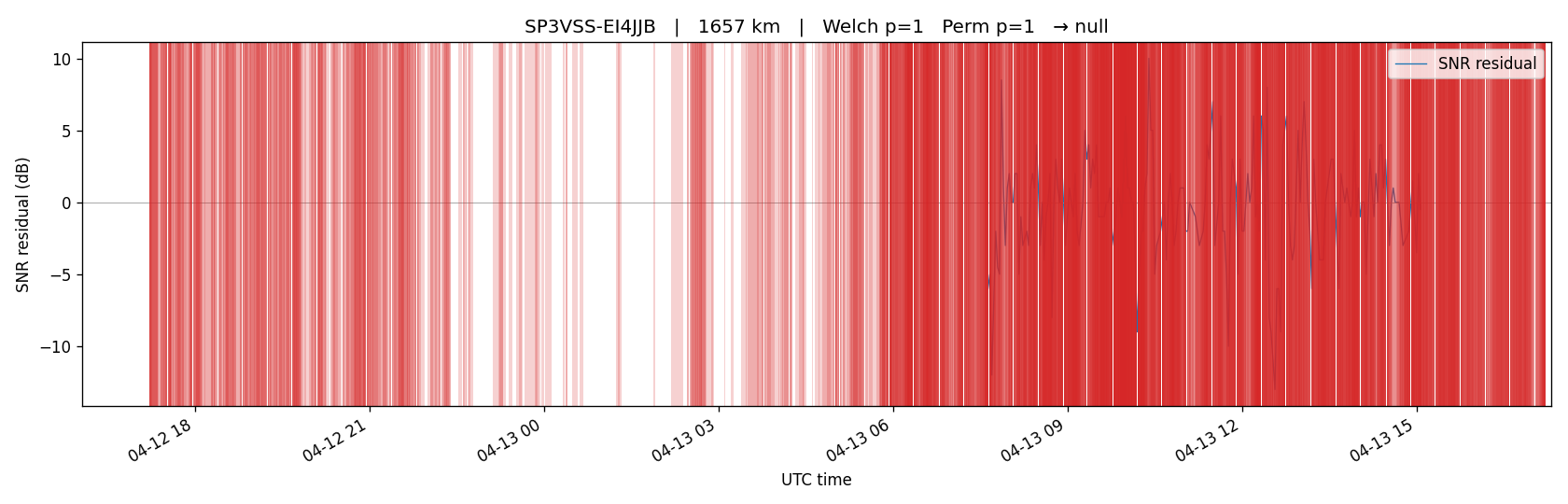
WSPR corridor SNR vs continuous solar wind Bz — natural V3 of #132

V3 follow-up to #132. Continuous-driver framing replaces small-N storm catalog with daily Bz signal on ~180 daily WSPR corridor samples.

Visualization for WSPR corridor SNR vs continuous solar wind Bz — natural V3 of #132
Interactive viz 8 data files
Researchcomplete
May 2026

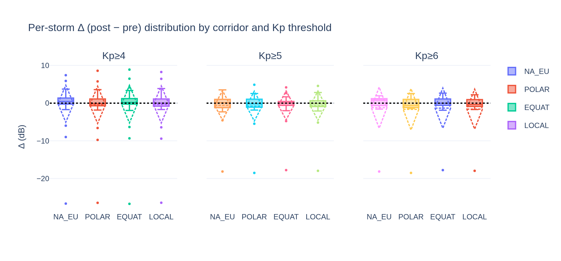
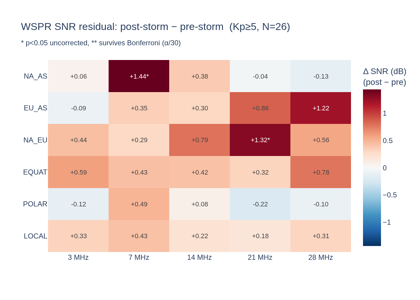
PMA #132 cross-protocol V2: WSPR Kp catalog under per-storm-delta protocol

Cross-protocol V2 of PMA #132. Holds input data and Kp event catalog constant with #132 V1; swaps only the analytical protocol to match PMA #82's per-storm scalar-delta one-sample t/Wilcoxon with Bonferroni over 4 corridors. Isolates which of four methodological factors drives the #82 (Bonferroni-significant POLAR -0.29 dB on Dst, 6yr, N=200) vs #132 V1 (clean null on Kp, 6.5mo, N=26) divergence.

Visualization for PMA #132 cross-protocol V2: WSPR Kp catalog under per-storm-delta protocol
Interactive viz 6 data files
Space Weathercomplete
May 2026

WSPR corridor SNR — superposed-epoch over Kp events

How does WSPR SNR on defined long-distance corridors respond to geomagnetic storms? Superposed-epoch analysis centered on Kp excursions.

Visualization for WSPR corridor SNR — superposed-epoch over Kp events
Interactive viz 6 data files
Seismologycomplete
May 2026

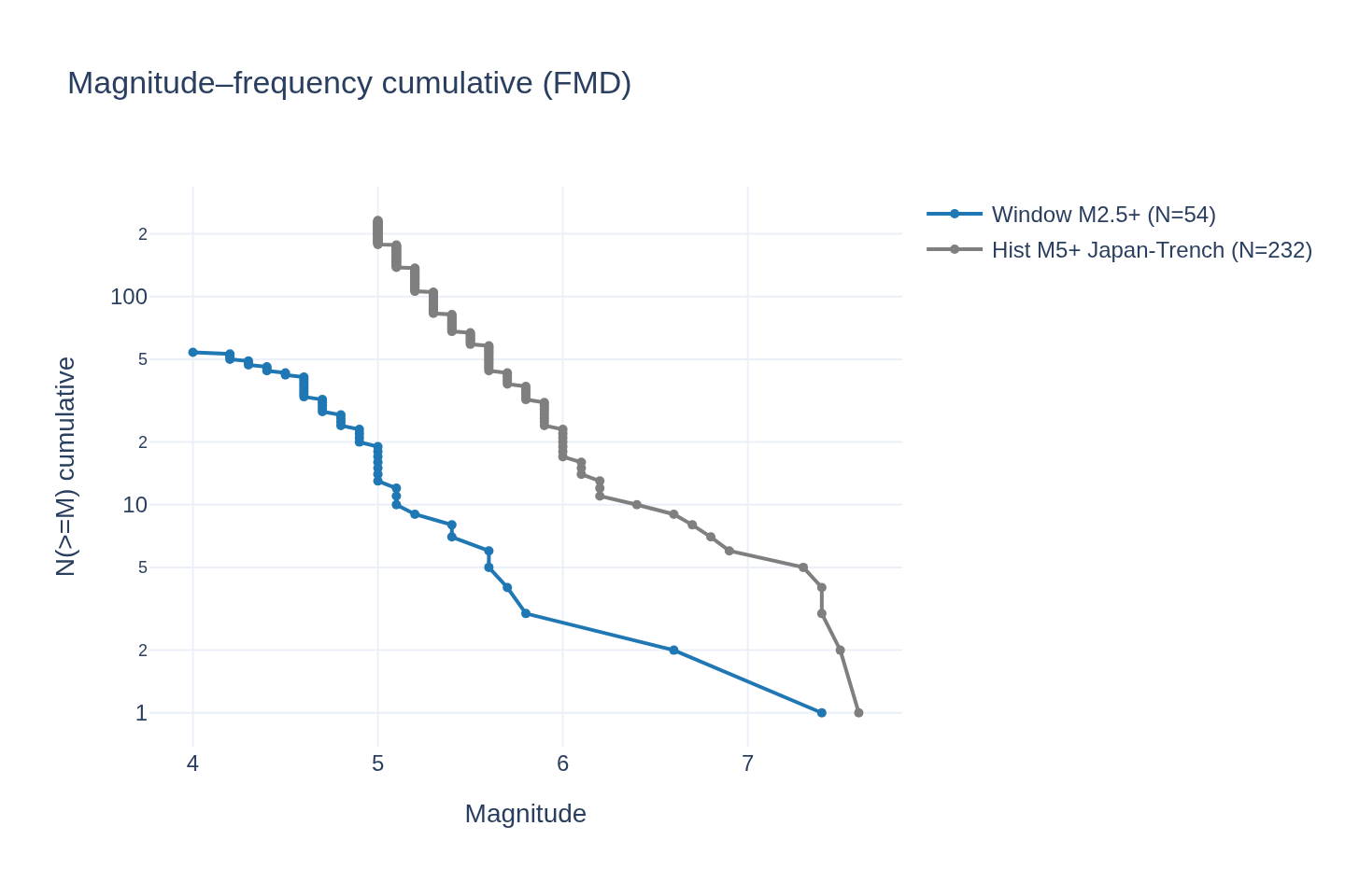
M6.6 Sanriku 2026-05-15 — foreshock signature and Bath's-law test

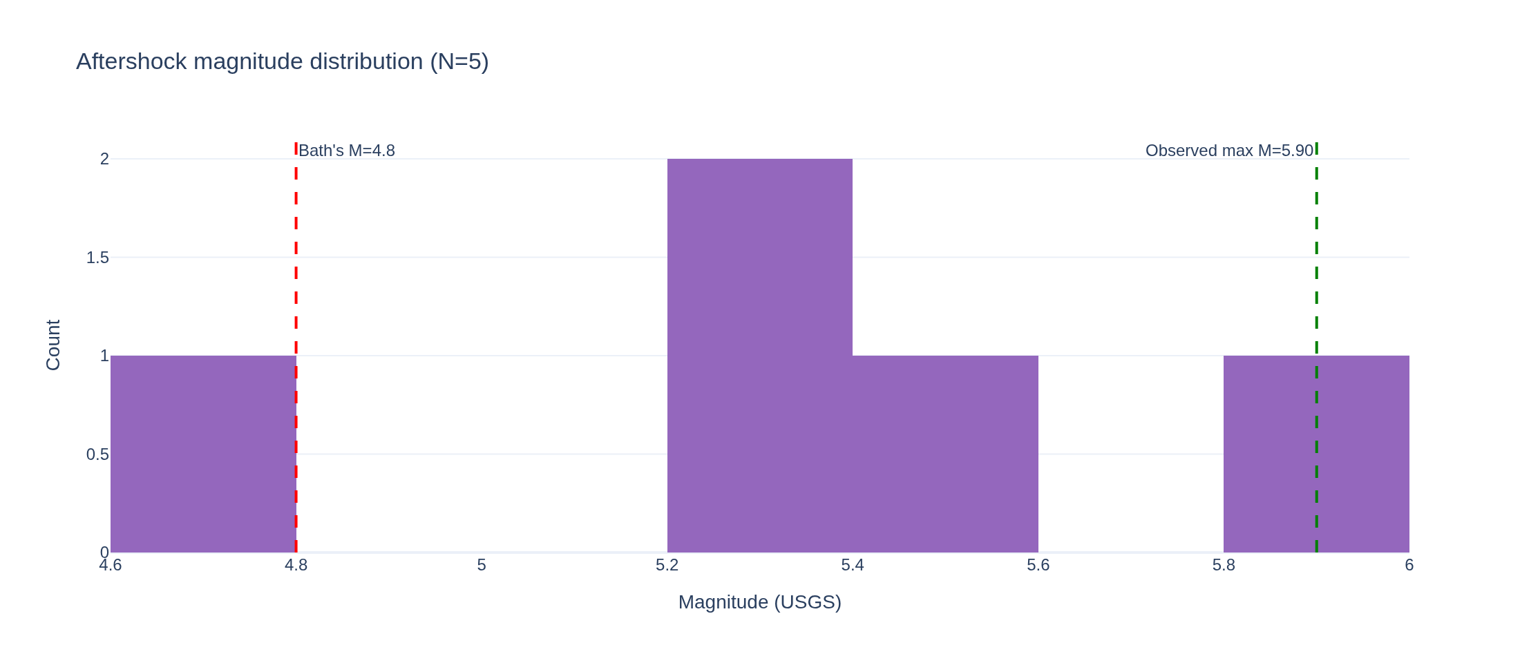
On 2026-05-15 a M6.6 earthquake struck offshore Sanriku, NE Japan (~39.03N, 141.81E), in the Pacific-Plate subduction zone where the 2011 Tohoku M9.1 mainshock occurred.

Visualization for M6.6 Sanriku 2026-05-15 — foreshock signature and Bath's-law test
Interactive viz 6 data files
Researchdraft
May 2026

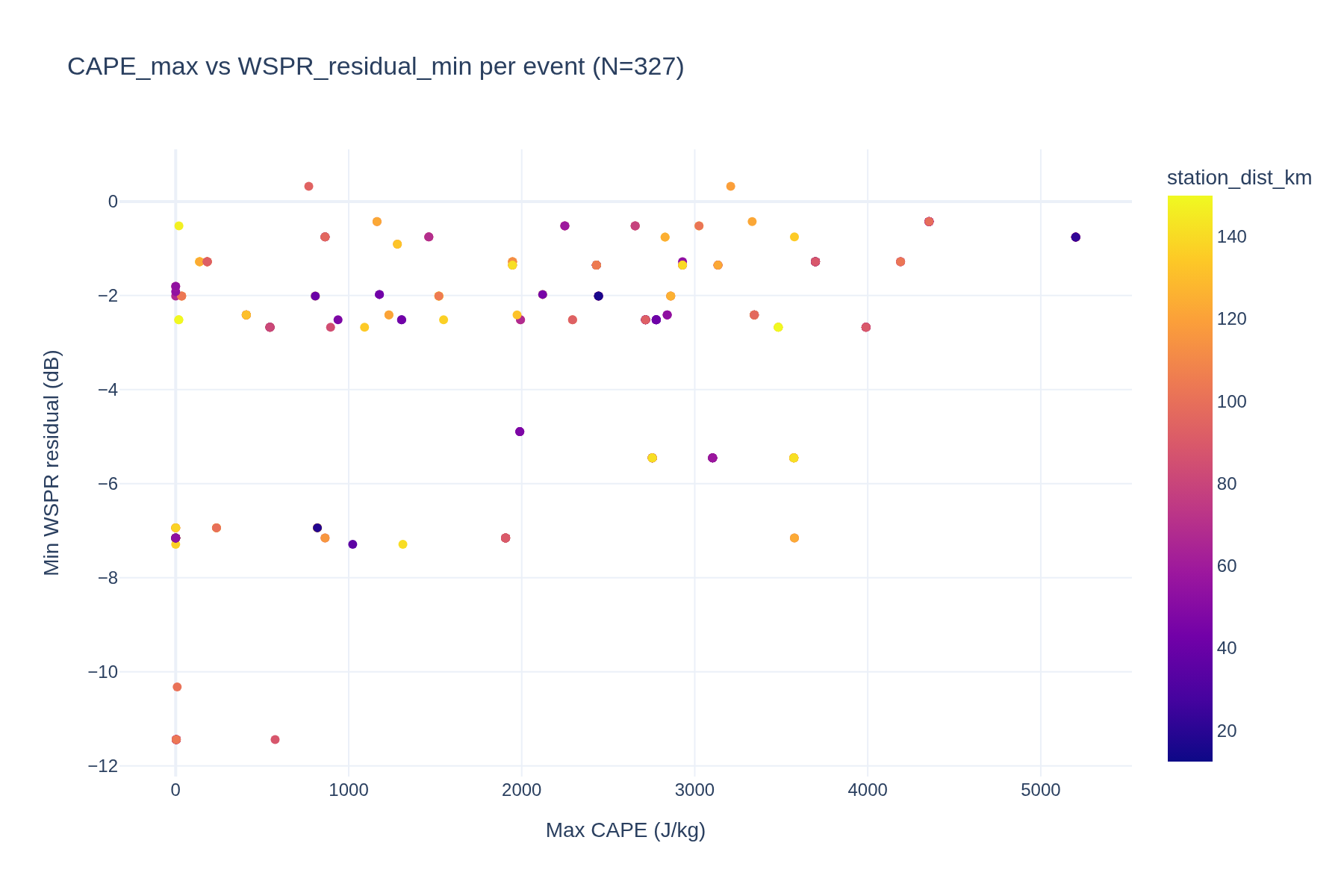
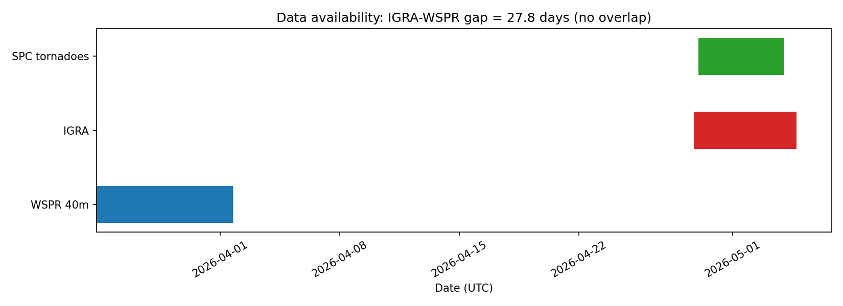
V2: Pre-tornadic CAPE evolution from IGRA soundings vs WSPR precursor timing

V2 re-run of #180 with IGRA sounding data now available (1.2M rows). Test if WSPR 40m precursor timing aligns with CAPE peak timing.

Visualization for V2: Pre-tornadic CAPE evolution from IGRA soundings vs WSPR precursor timing
Interactive viz 4 data files
Researchdraft
May 2026

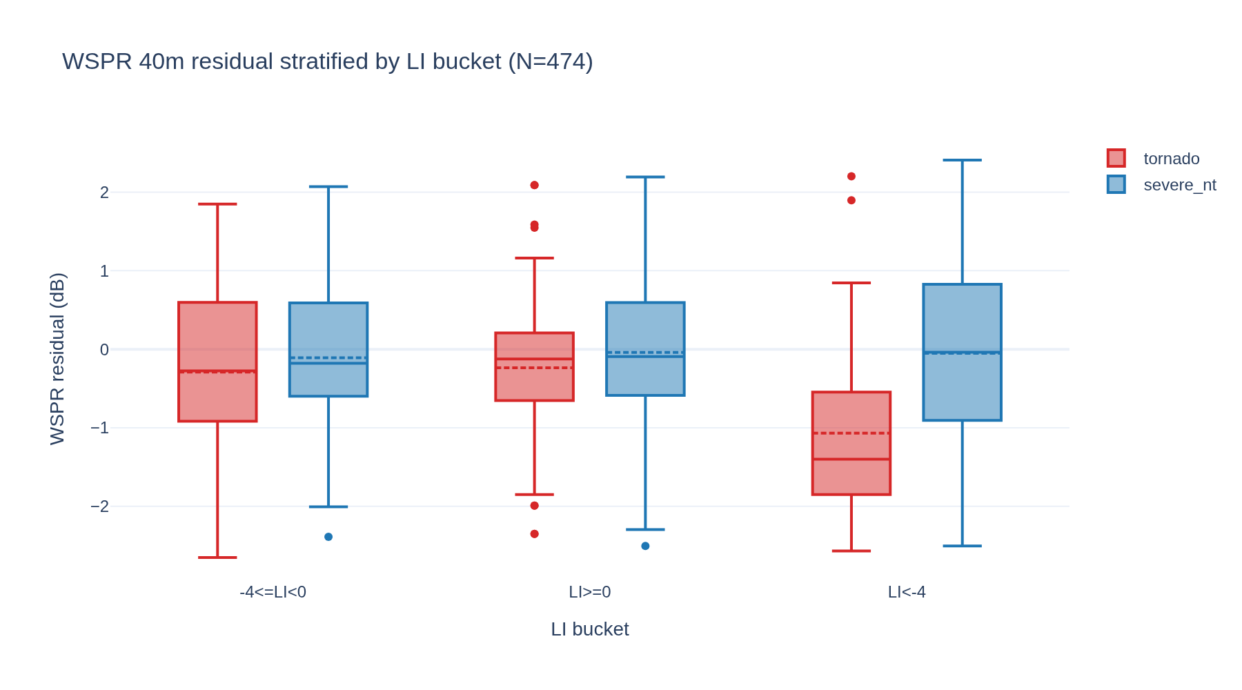
V2: Lifted Index as a control variable for the WSPR-tornado precursor
V2 of #181: re-run with full IGRA data (1.2M rows) and live WSPR. Test whether WSPR 40m precursor is independent of LI or proxy.

Visualization for V2: Lifted Index as a control variable for the WSPR-tornado precursor
Interactive viz 10 data files
Researchcomplete
May 2026

Lifted Index as a control variable for the WSPR-tornado precursor

Is the WSPR 40m precursor independent of LI, or a proxy for atmospheric instability? H1: independent. H0: LI explains all of the WSPR-tornado correlation.

Visualization for Lifted Index as a control variable for the WSPR-tornado precursor
Interactive viz 7 data files
Researchcomplete_inconclusive
May 2026

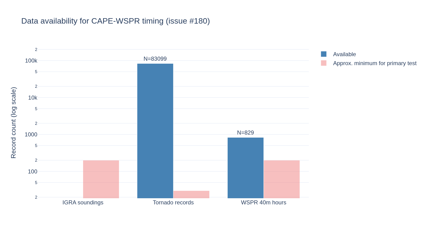
Pre-tornadic CAPE evolution from IGRA soundings vs WSPR precursor timing

Does atmospheric instability (CAPE / lifted index) ramp on the same 4-6h pre-tornado timeline as the WSPR 40m precursor signal? H1: timing match. H0: independent timing.

Visualization for Pre-tornadic CAPE evolution from IGRA soundings vs WSPR precursor timing
Interactive viz 5 data files
Researchrevised
Apr 2026

WSPR tornado V5 - non-tornadic severe convection controls

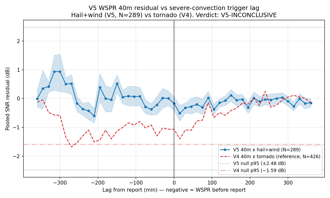
V5: are the V3/V4 40m WSPR pre-tornado precursors tornado-specific or generic to deep severe convection? Magnitude-matched non-tornadic hail+wind days as trigger

Visualization for WSPR tornado V5 - non-tornadic severe convection controls
Interactive viz 62 data files
Researchdraft
Apr 2026

WSPR tornado V4: mechanism test — WSPR × GOES-16 GLM lightning cross-correlation

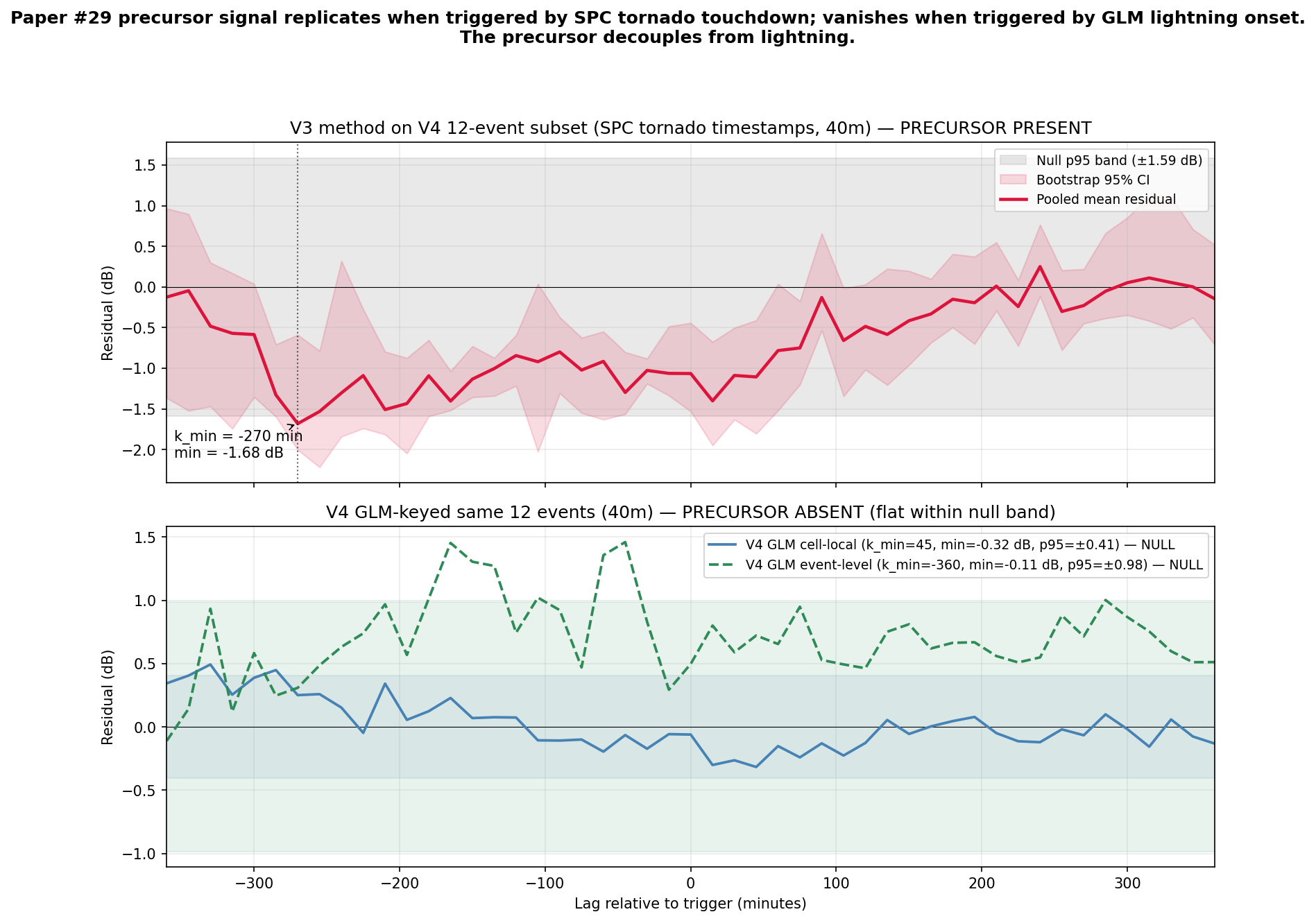
V4 discriminates D-layer absorption (WSPR leads lightning) from QRN (simultaneous) using GLM historical lightning data on the V3 outbreaks. Data source: GOES-16 GLM L2 LCFA from noaa-goes16 public S3 bucket.

Visualization for WSPR tornado V4: mechanism test — WSPR × GOES-16 GLM lightning cross-correlation
57 data files
Researchdraft
Apr 2026

WSPR tornado V3: calm-season + density-matched controls (12 outbreaks, 24 controls)

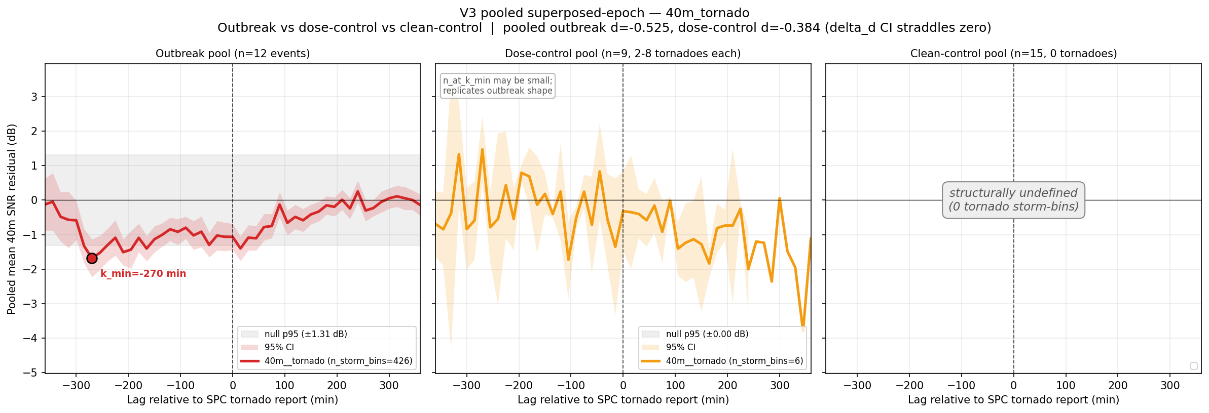
V3 with fixed control design — calm-season controls, SPC-pre-screened, density-matched

Visualization for WSPR tornado V3: calm-season + density-matched controls (12 outbreaks, 24 controls)
Interactive viz 193 data files
Researchdraft
Apr 2026

WSPR tornado V2: historical outbreak case studies (Joplin, Super Outbreak, Moore, Rolling Fork, ...)

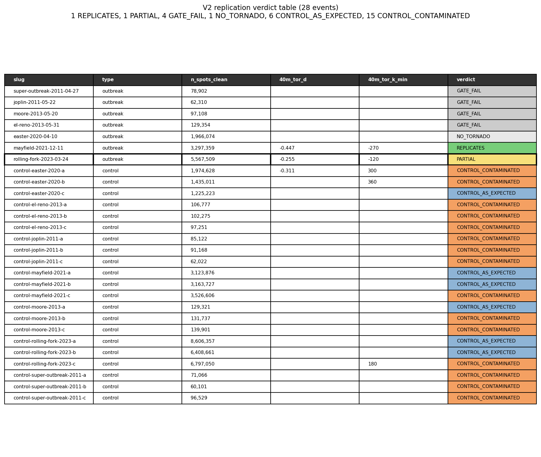
V2 verification of the paper #29 40m precursor finding using 7 historical outbreaks + 21 matched controls

Visualization for WSPR tornado V2: historical outbreak case studies (Joplin, Super Outbreak, Moore, Rolling Fork, ...)
Interactive viz 148 data files
Researchdraft
Apr 2026

WSPR tornado season — CONUS 10-day SNR/density map with severe weather overlay

Does WSPR HF propagation show a detectable SNR/density depression in grid cells under active severe weather? 10-day CONUS dataset with SPC + NWS overlay. GH issues #133-138.

Visualization for WSPR tornado season — CONUS 10-day SNR/density map with severe weather overlay
Interactive viz 18 data files
Space Weathercomplete
Apr 2026

Solar Wind to Kp Storm Onset Lag Time Distribution

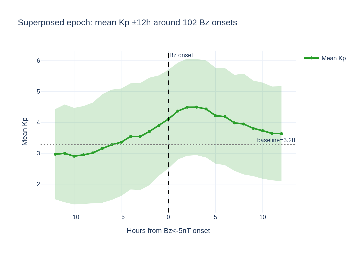
Research question: What is the empirical distribution of lag times between a southward IMF Bz excursion (DSCOVR L1 measurement) and the resulting Kp index increase indicating geomagnetic storm onset?

Visualization for Solar Wind to Kp Storm Onset Lag Time Distribution
Interactive viz 4 data files
Hydrologycomplete
Apr 2026

Lunar Tidal Forcing Signature in USGS Streamflow

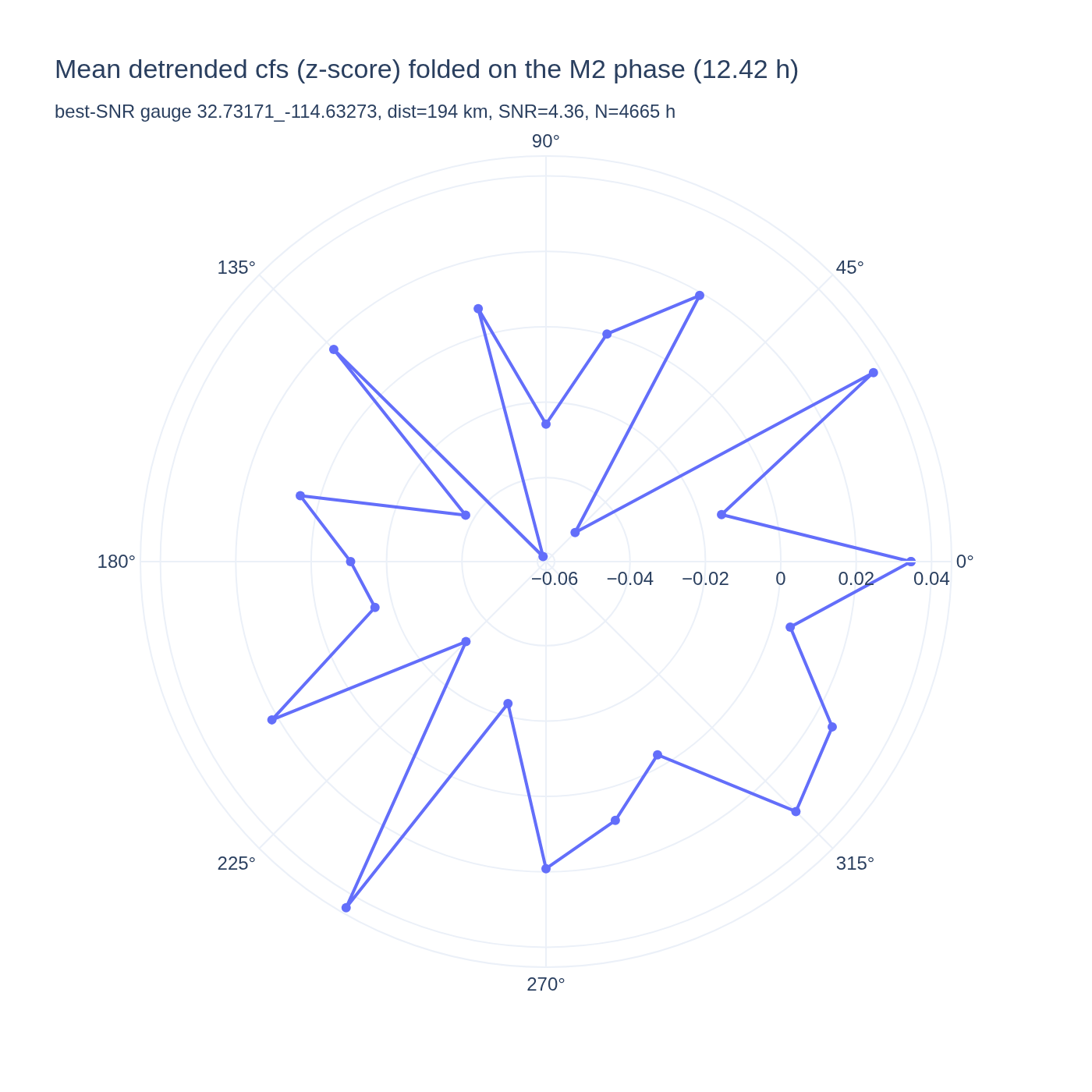
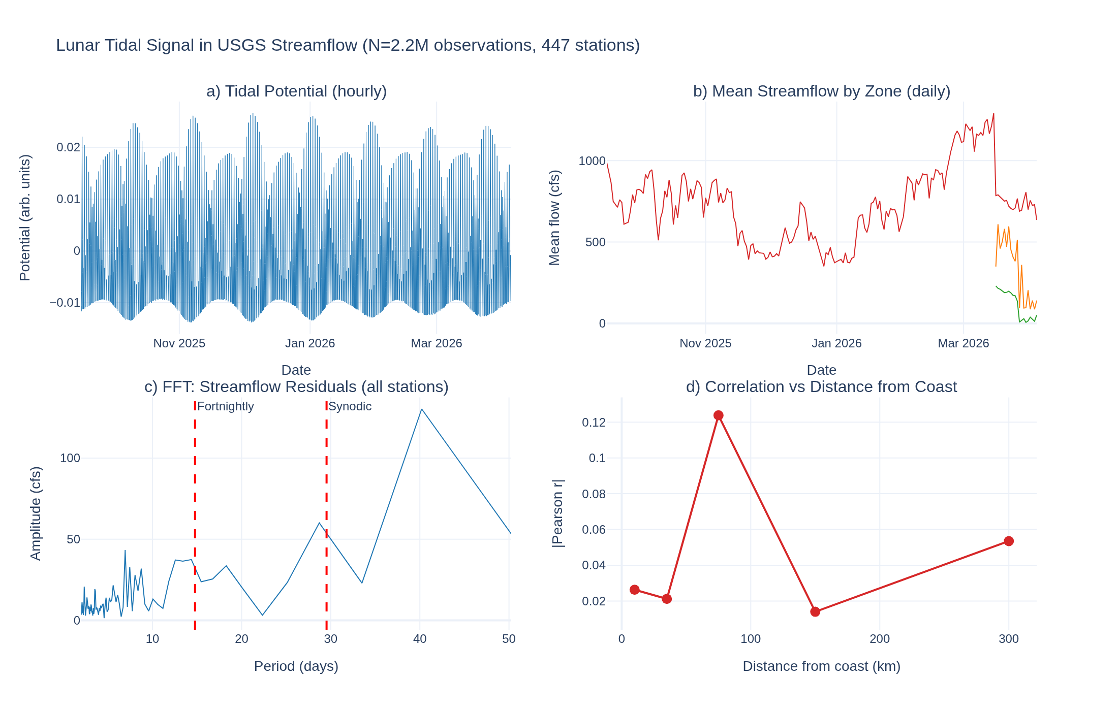
Does the lunar gravitational tide produce a detectable periodic signal in inland river streamflow at M2 period (12.42h)?

Visualization for Lunar Tidal Forcing Signature in USGS Streamflow
Interactive viz 4 data files
Seismologycomplete
Apr 2026

Kermadec Doublet — M6.0 + M5.9 same epicenter, 48h apart

On 2026-04-16 a M6.0 earthquake struck south of the Kermadec Islands (-32.21, -178.05, depth 10 km). 48 hours later (2026-04-18), a M5.9 struck the same

Visualization for Kermadec Doublet — M6.0 + M5.9 same epicenter, 48h apart
Interactive viz 6 data files
Seismologyactive
Apr 2026

April 2026 Offshore Washington Swarm: Ridge, Not Subduction Zone

Fact-check of claims that an earthquake swarm off Washington coast is occurring in the Cascadia Subduction Zone. USGS data shows the swarm at ~129°W on the Juan de Fuca Ridge, ~400 km west of the CSZ trench.

Interactive viz 1 data files
Researchaccepted
Apr 2026

Can WSPR Detect Aircraft? A Pre-Registered Test Against ADS-B Ground Truth

Before evaluating any WSPR-aircraft tracking hypothesis (e.g., MH370), we must answer the prior question: can WSPR detect commercial aircraft at all? This pre-registered analysis tests whether WSPR SNR variations correlate with known flight crossings of station-pair great circle paths.

Visualization for Can WSPR Detect Aircraft? A Pre-Registered Test Against ADS-B Ground Truth
Interactive viz 21 data files
Researchcomplete
Apr 2026

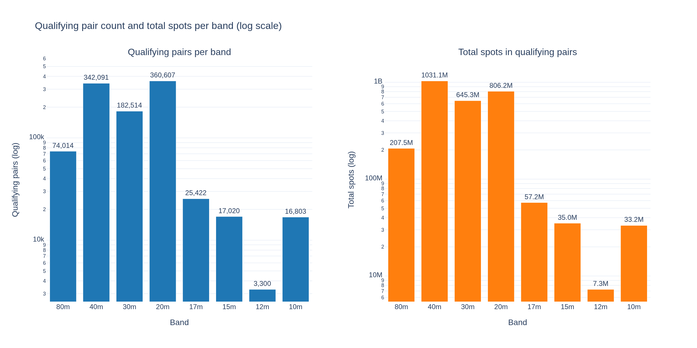
WSPR 21-Year Census — 11.53 Billion Spots, Nov 2004 to Apr 2026

Complete statistical census of the WSPRnet raw spot archive: 11.53 billion spots across 221 months, aggregated in 64 minutes of wall time on a single workstation. Foundational reference for all WSPR papers.

Visualization for WSPR 21-Year Census — 11.53 Billion Spots, Nov 2004 to Apr 2026
Interactive viz 1 data files
Seismologydraft
Apr 2026

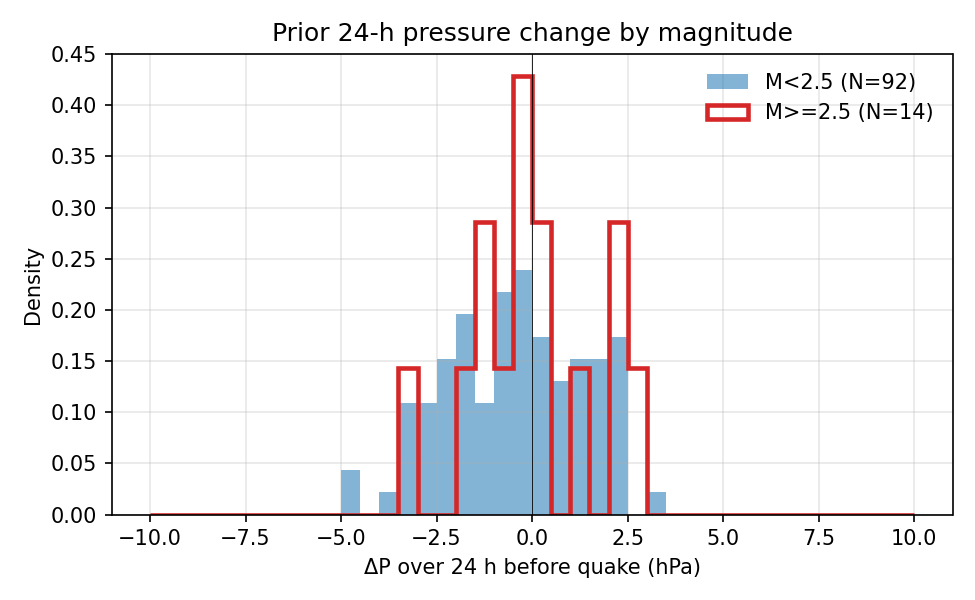
Earthquake-Weather Coupling: Barometric Pressure Trigger Hypothesis

Test whether rapid drops in atmospheric pressure trigger small earthquakes. The folk-science hypothesis says storm fronts reduce confining stress on shallow faults and should elevate seismicity by 0.1-1%. Controlled studies generally find no effect.

Visualization for Earthquake-Weather Coupling: Barometric Pressure Trigger Hypothesis
5 data files
Cross-Domainaccepted
Apr 2026

Granger V4 — Full Environmental Network with CO2, CH4, Tidal Proxy, Pressure

V4 extends the TerraPulse Granger-causality network analysis (V1-V3) by adding atmospheric composition (CO2, CH4), a lunar tidal-potential proxy, and barometric pressure to the 8-metric space-weather+surface network from V3. Emphasis is on honest per-pair overlap accounting, Bonferroni correction based on tests actually run, joint F-tests over all lags, stationarity checks, a shuffle null, and AR self-predictability baselines.

Interactive viz 3 data files
Researchdraft
Apr 2026

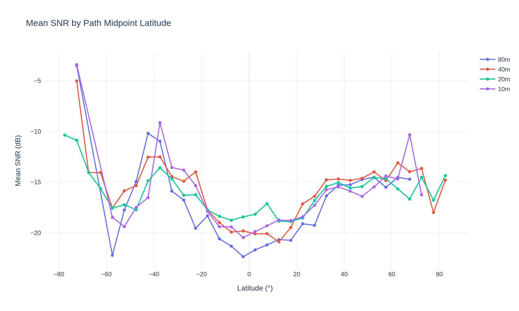
WSPR Ionospheric Geography — Global Propagation Atlas from 11.5B Spots

Visualization for WSPR Ionospheric Geography — Global Propagation Atlas from 11.5B Spots
Interactive viz 1 data files
Space Weatherdraft
Apr 2026

WSPR Solar Cycle Modulation — How the 11-Year Cycle Reshapes HF Propagation

Visualization for WSPR Solar Cycle Modulation — How the 11-Year Cycle Reshapes HF Propagation
Interactive viz 4 data files
Researchaccepted
Apr 2026

Two Competing Responses Hidden in the 10 m WSPR Anticorrelation: Station-Pair Validation Reveals a Short-Path versus Long-Path Sign Flip

Visualization for Two Competing Responses Hidden in the 10 m WSPR Anticorrelation: Station-Pair Validation Reveals a Short-Path versus Long-Path Sign Flip
Interactive viz 5 data files
Cross-Domaindraft
Apr 2026

NWS Alert Cascades: Cross-Domain Temporal Prediction Networks

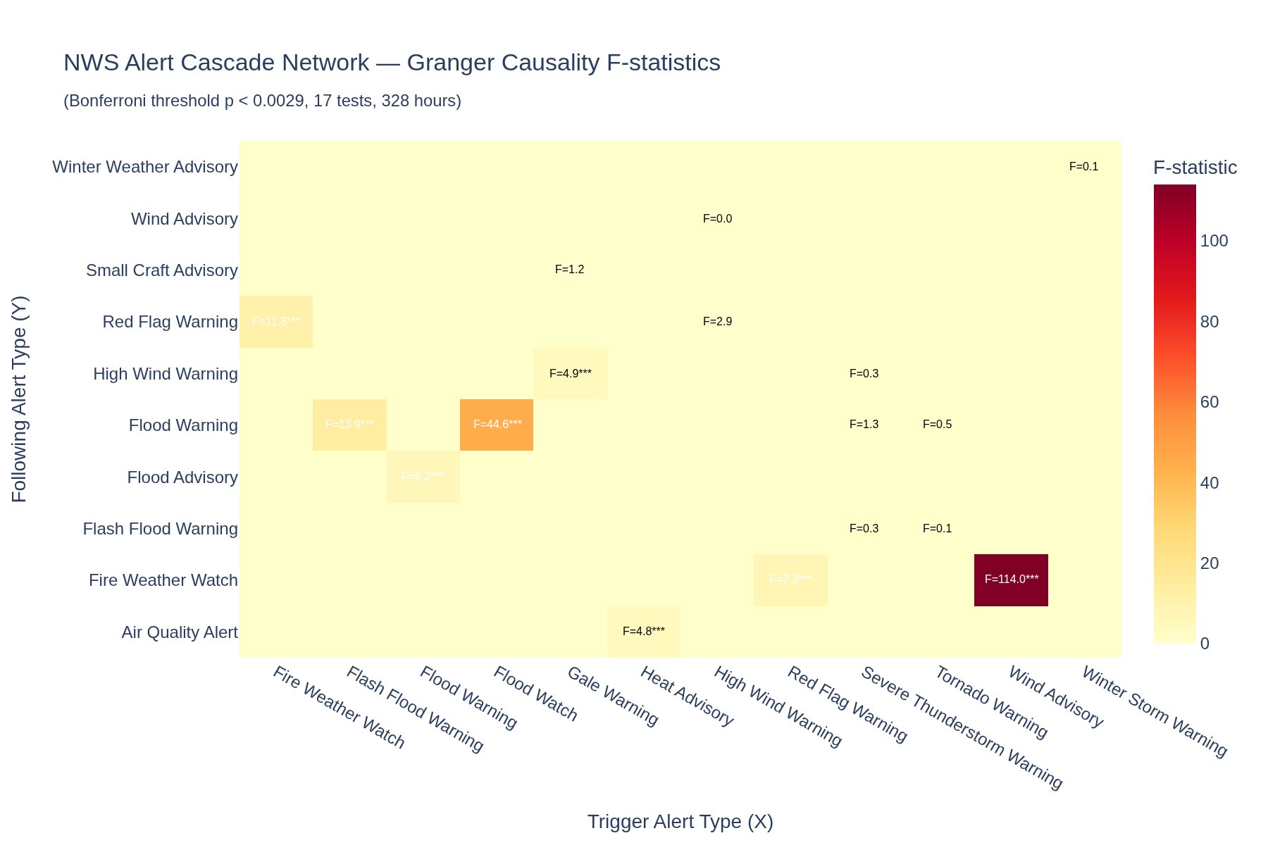
Do flood warnings predict landslide advisories? Do heat advisories predict air quality alerts? Build a temporal cascade network from the NWS alert stream.

Visualization for NWS Alert Cascades: Cross-Domain Temporal Prediction Networks
Interactive viz 5 data files
Space Weatheraccepted
Apr 2026

NEO close approaches — flyby distance/velocity patterns and fireball correlation

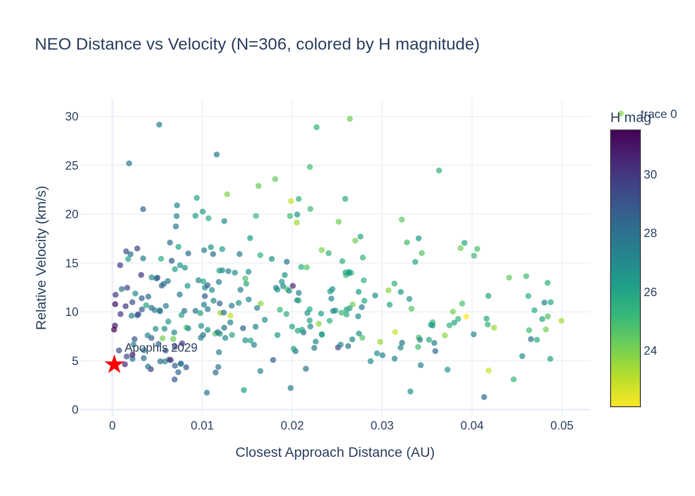
Do near-Earth object close approach patterns correlate with fireball events? Are there temporal clusters in flyby distance or velocity?

Visualization for NEO close approaches — flyby distance/velocity patterns and fireball correlation
Interactive viz 4 data files
Space Weatherdraft
Apr 2026

Solar Cycle Prediction: Can 208 Years of Sunspot Data Beat NOAA Forecasts?

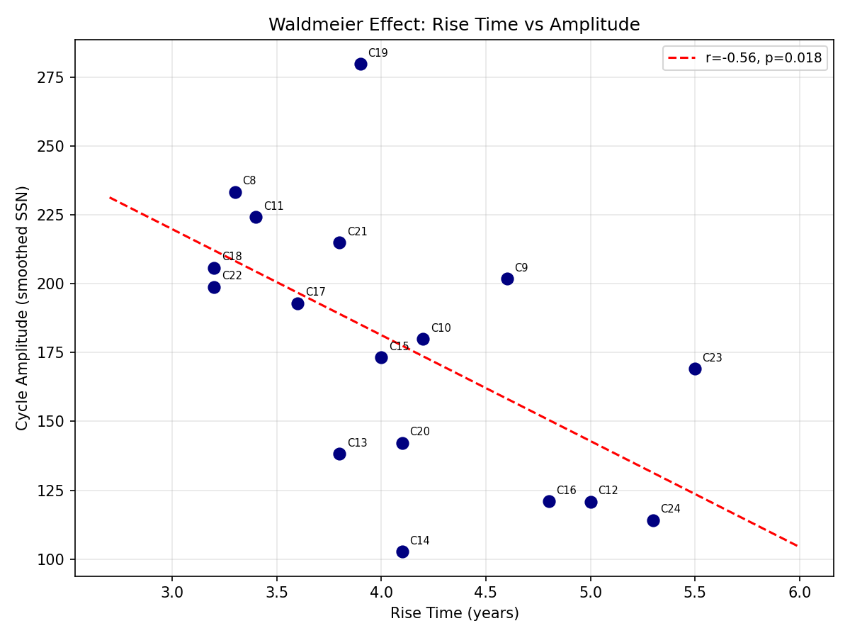
Can simple time-series methods (ARIMA, spectral decomposition, or ML) on our 208-year sunspot record produce a competitive forecast for Solar Cycle 25? Benchmark against NOAA predicted range.

Visualization for Solar Cycle Prediction: Can 208 Years of Sunspot Data Beat NOAA Forecasts?
4 data files
Hydrologyaccepted
Apr 2026

Lunar tidal signal in inland rivers -- gravitational forcing on USGS streamflow

Can we detect a lunar tidal signal in inland river streamflow? The gravitational tidal force acts on all mass, not just oceans -- but the effect on rivers should be extremely small.

Visualization for Lunar tidal signal in inland rivers -- gravitational forcing on USGS streamflow
Interactive viz 4 data files
Seismologyaccepted
Apr 2026

Radon precursor hypothesis — Safecast radiation vs earthquake timing

Does background radiation (Safecast citizen-science network) show detectable anomalies in the days before significant earthquakes?

Visualization for Radon precursor hypothesis — Safecast radiation vs earthquake timing
Interactive viz 4 data files
Researchaccepted
Apr 2026

Starlink Cannot Explain Pre-2014 UFO Sightings: Satellite Phenotype Characterization

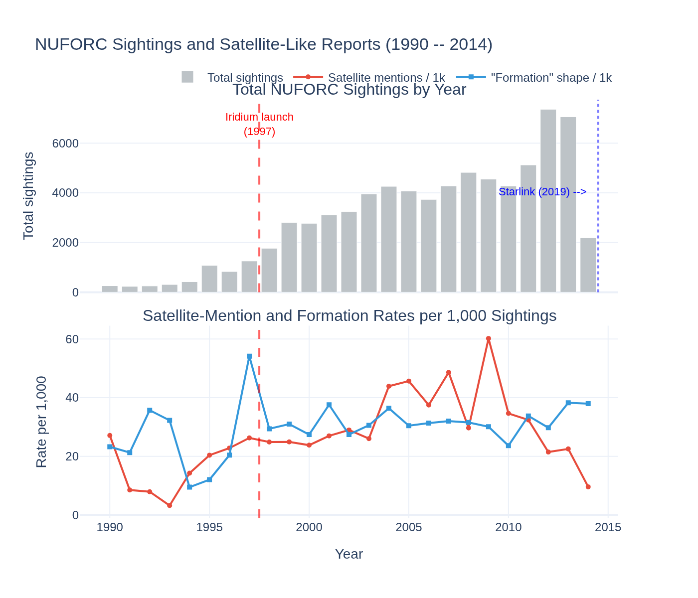
Starlink attribution to NUFORC sightings is impossible: NUFORC ends 2014, Starlink launched 2019. Pre-2014 satellite phenotype analysis: 826 sightings (1.03%) with explicit satellite mentions, 3,862 (4.81%) matching broad satellite phenotype. Formation shape increased 1.6x post-Iridium (chi2(1)=23.0, p=1.6e-6, N=76,097). Even broadest filter reduces unexplained from 75.9% to 71.1%. Starlink (10,119 sats) would dominate post-2019 reports but cannot be tested against this dataset.

Visualization for Starlink Cannot Explain Pre-2014 UFO Sightings: Satellite Phenotype Characterization
Interactive viz 1 data files
Climatedraft
Apr 2026

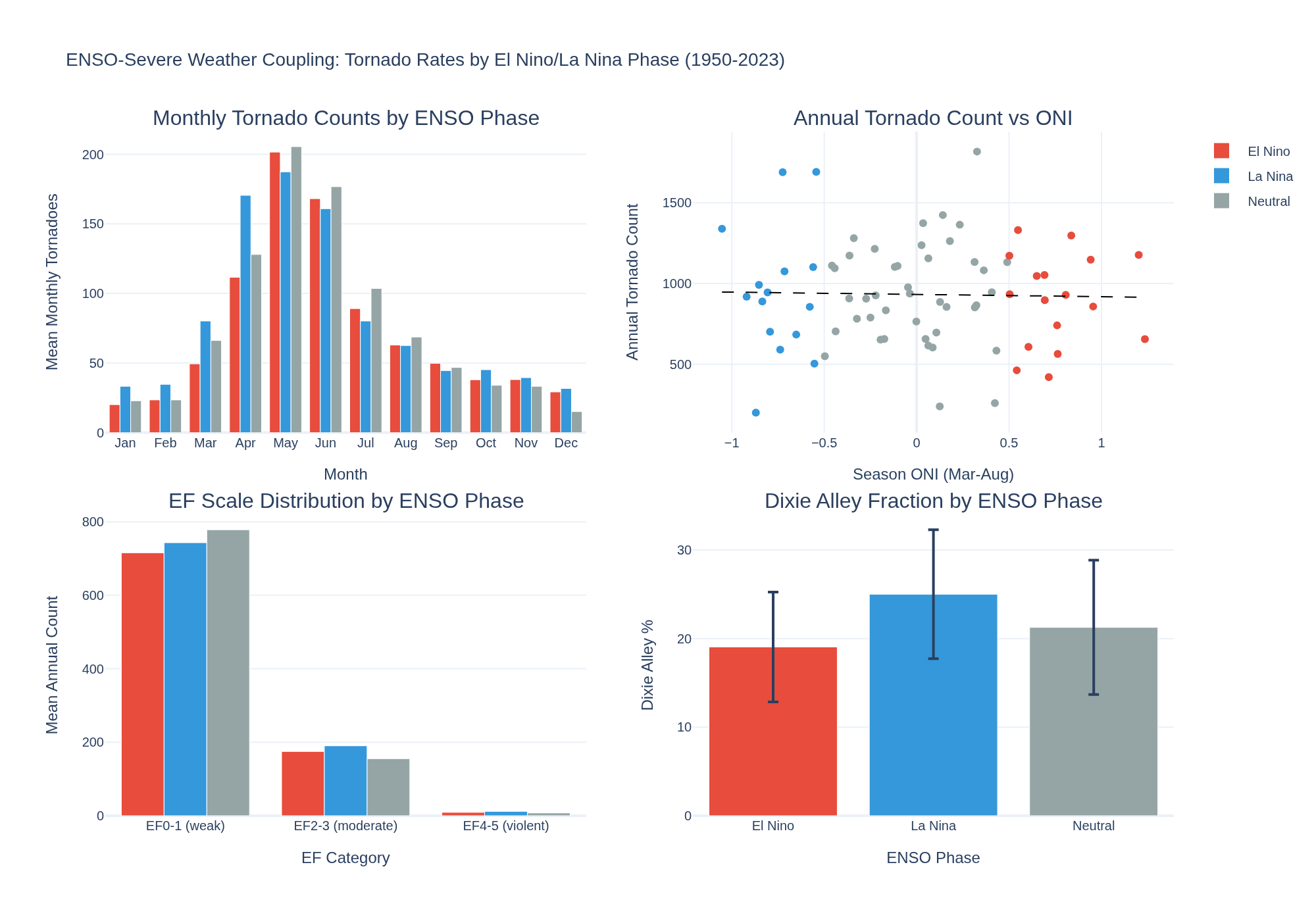
ENSO-Severe Weather Coupling: NWS Alerts vs El Nino/La Nina Phases

Does ENSO modulate NWS alert rates? Monthly alert counts stratified by ONI phase. La Nina -> more tornadoes? El Nino -> more floods? Fire weather vs drought index.

Visualization for ENSO-Severe Weather Coupling: NWS Alerts vs El Nino/La Nina Phases
Interactive viz 6 data files
Researchdraft
Apr 2026

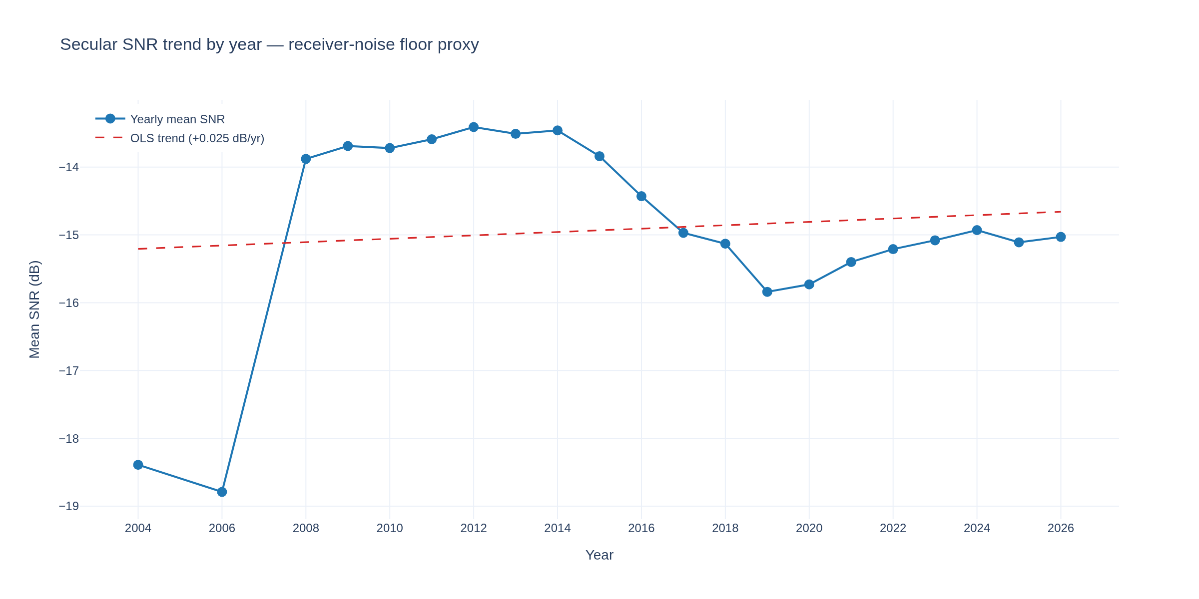
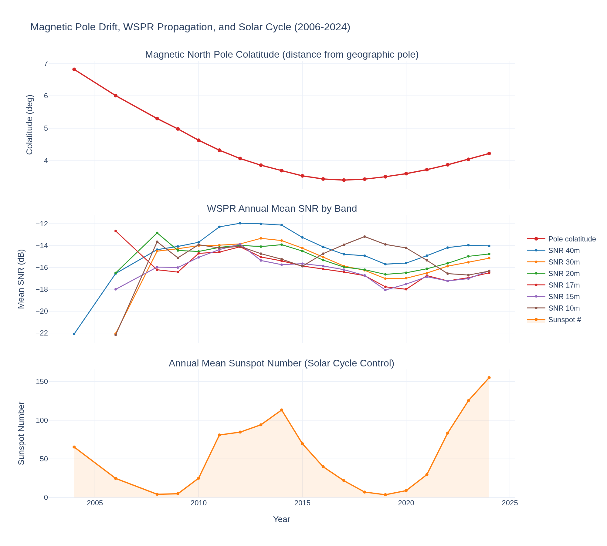
Magnetic pole drift vs WSPR 21-year propagation trend

The magnetic north pole has accelerated toward Siberia (~55 km/yr). Our WSPR data shows -0.1 dB/year across all HF bands over 21 years.

Visualization for Magnetic pole drift vs WSPR 21-year propagation trend
Interactive viz 6 data files
Seismologyaccepted
Apr 2026

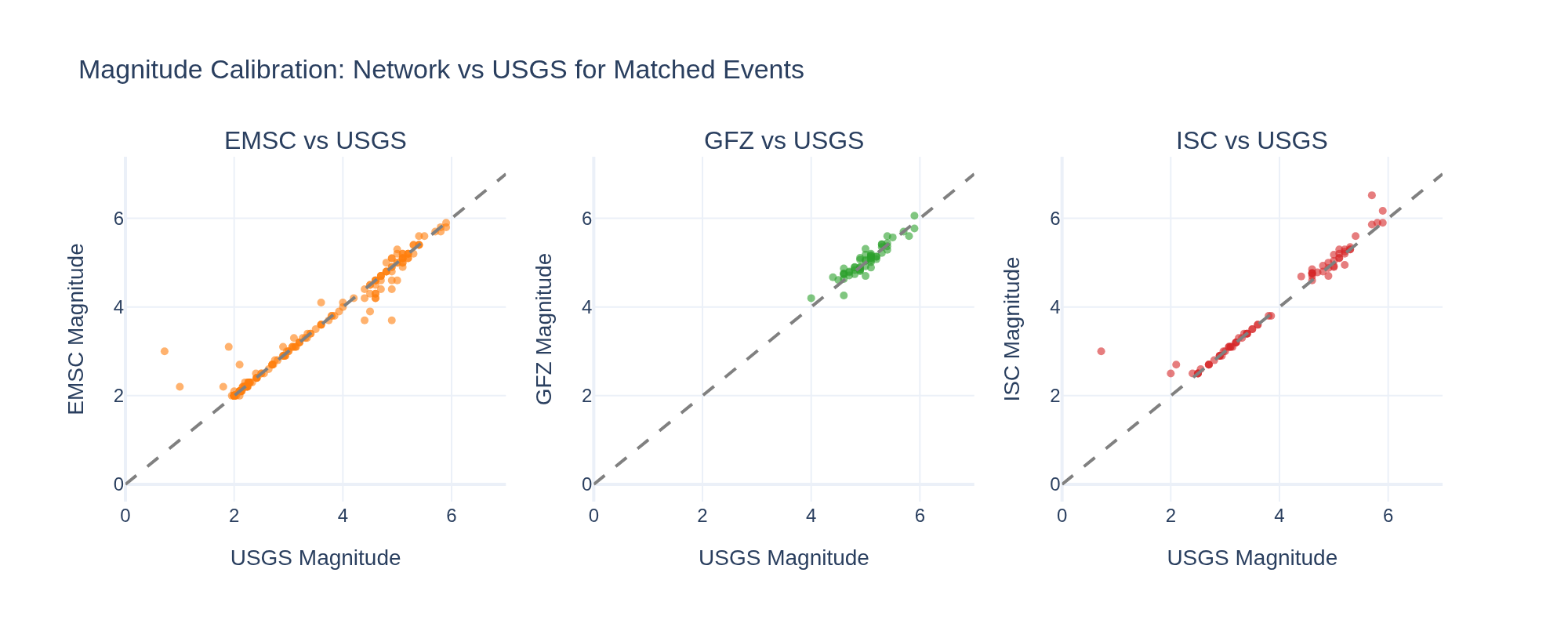
Multi-network seismic comparison — USGS vs EMSC vs GFZ vs ISC catalog completeness

We now ingest from 4 seismic networks. Compare: detection thresholds by region, magnitude agreement for shared events, temporal coverage gaps.

Visualization for Multi-network seismic comparison — USGS vs EMSC vs GFZ vs ISC catalog completeness
Interactive viz 13 data files
Space Weatherrevised
Apr 2026

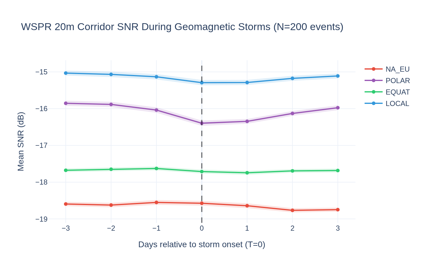
WSPR Storm Response — Corridor SNR During Geomagnetic Storms

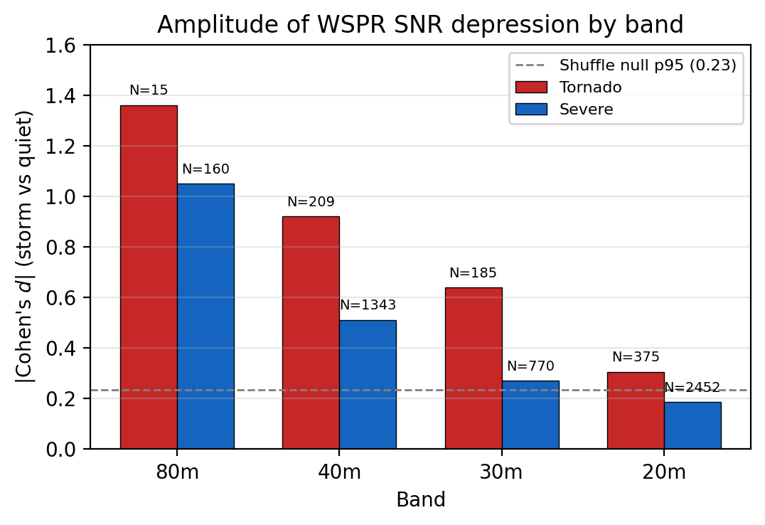
POLAR paths degrade 0.29 dB during geomagnetic storms (t=4.9, p=2e-6, d=-0.35, N=200 per-storm deltas). EQUAT null (Wilcoxon p=0.088, Bonferroni p=0.35) validates corridor-differential method. Differential POLAR-EQUAT = -0.23 dB. Effect monotonically increases with storm severity (d=-0.62 at Dst<-100). NA_EU nominally significant (p=0.024) but does not survive Bonferroni correction.

Visualization for WSPR Storm Response — Corridor SNR During Geomagnetic Storms
Interactive viz 4 data files
Space Weatherrevision-1
Apr 2026

NUFORC Cross-Correlation — Filter UFO Sightings Against Known Phenomena

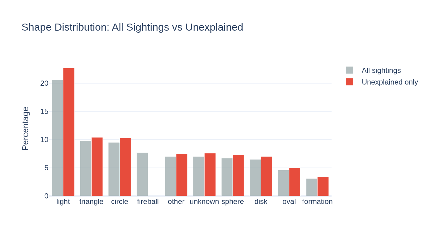
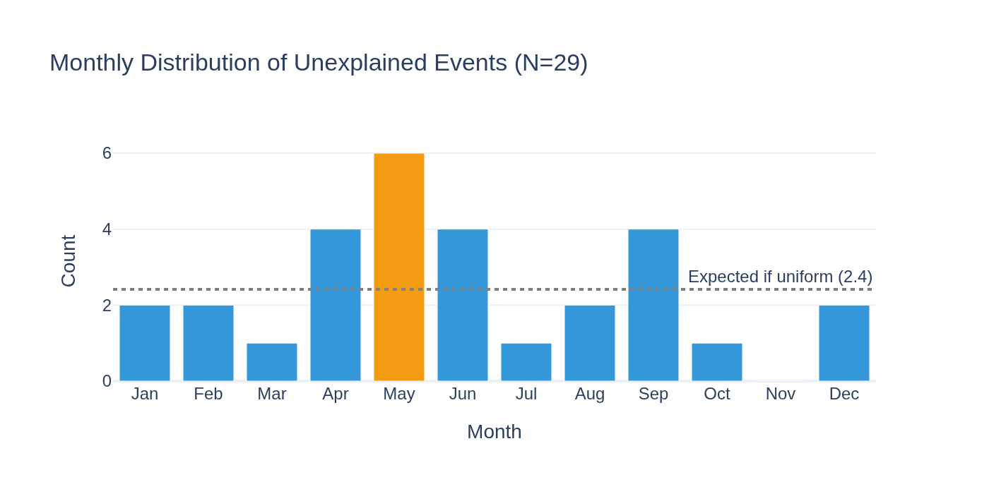
80K NUFORC sightings filtered: 6.2% self-classified fireballs (exclusive), 16.3% storm/aurora (exclusive), 0 CNEOS matches. 75.9% unexplained with strong summer seasonal bias (chi2(11)=3466, days-per-month null). Storm match rate (19.5% of covered) below random baseline (31.2%).

Visualization for NUFORC Cross-Correlation — Filter UFO Sightings Against Known Phenomena
Interactive viz 5 data files
Space Weatheraccepted
Apr 2026

WSPR Transient Deep Dive — Cross-Reference Unexplained Events

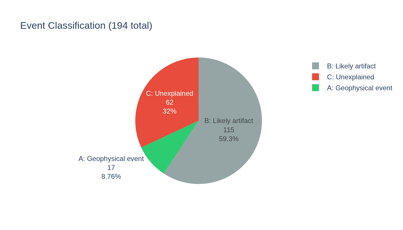
3 of 32 Cat C events reclassified (G5 storm, solar eclipse, Grimsvotn eruption). 29 remain unexplained: 79% positive enhancement (p=0.002), 55% at solar minimum, upper HF dominant. Sporadic F-region density enhancements.

Visualization for WSPR Transient Deep Dive — Cross-Reference Unexplained Events
Interactive viz 6 data files
Researchaccepted
Apr 2026

WSPR Anomaly Detection — Transient Hunting in 21 Years of Ionospheric Residuals

Cycle removal + anomaly detection on 108K WSPR rows finds 202 transient events. 17 attributed to known storms, 66 unexplained (statistically identical to attributed, p=0.71). Method validated by blind detection of May 2024 G5 superstorm (z=6.7σ).

Visualization for WSPR Anomaly Detection — Transient Hunting in 21 Years of Ionospheric Residuals
Interactive viz 8 data files
Space Weathercomplete
Mar 2026

WSPR Ionospheric Propagation Baseline — 21 Years of Global HF Health

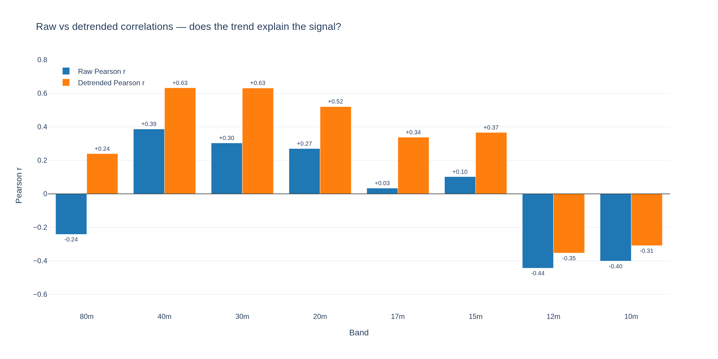
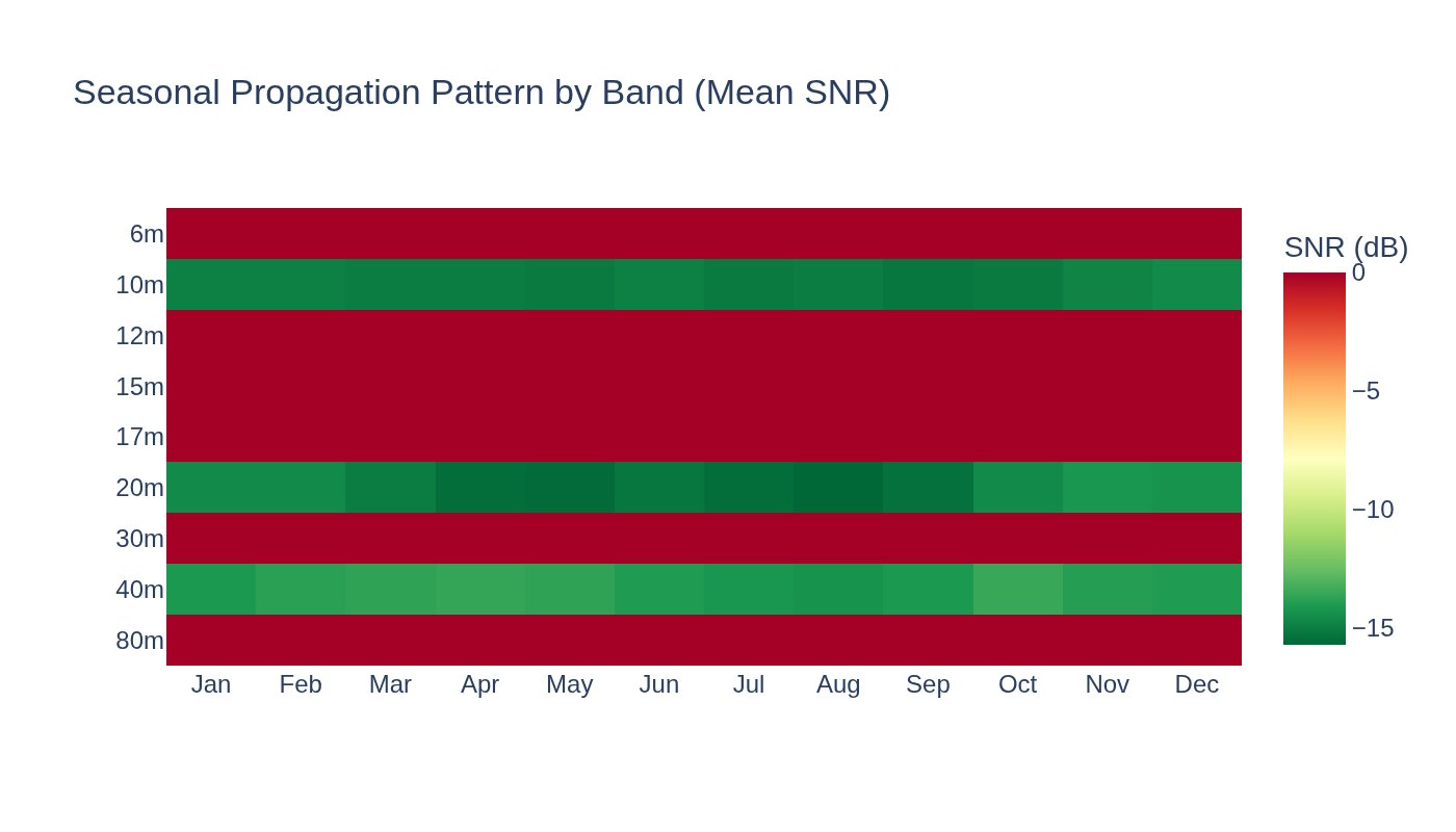
11.5B WSPR spots (2004-2026), 108K daily band aggregates. 40m/20m improve in solar max (r=+0.45), 10m degrades (r=-0.29). Network grew from 4 TX to 771. The ionosphere breathes with the Sun.

Visualization for WSPR Ionospheric Propagation Baseline — 21 Years of Global HF Health
Interactive viz 5 data files
Radiationaccepted
Mar 2026

DONKI Event Catalog — Cascade Triggers in the Sun-to-Ground Chain

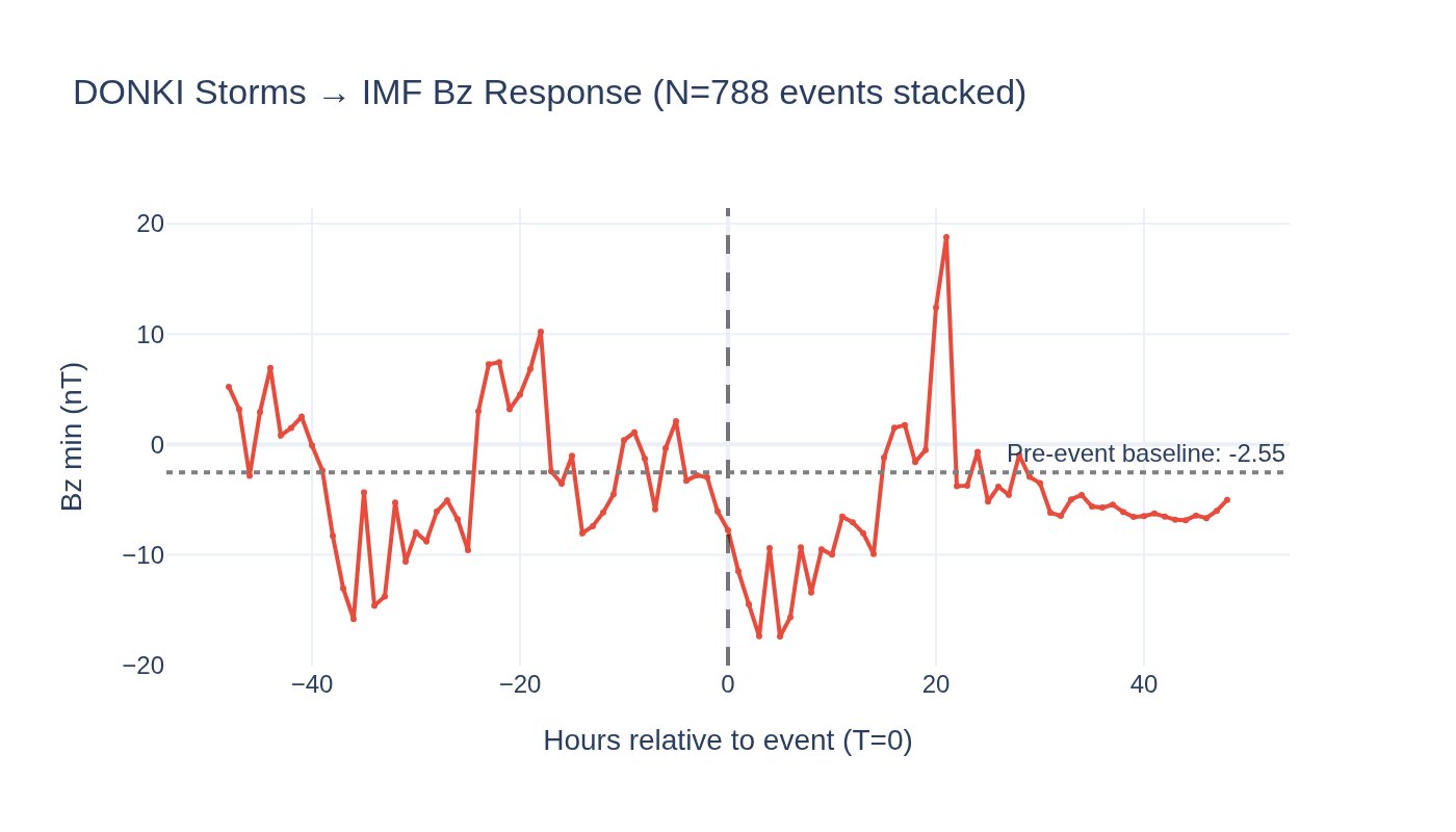
SEA of 1,809 DONKI events: storms peak Kp at T+6h (+47%), HSS +6%, radiation belt lags by 38h. CME speed negatively correlates with Kp (r=-0.18) due to catalog selection bias.

Visualization for DONKI Event Catalog — Cascade Triggers in the Sun-to-Ground Chain
Interactive viz 10 data files
Cross-Domaincomplete
Mar 2026

NWS Severe Weather Baseline — Alert Patterns and Geographic Distribution

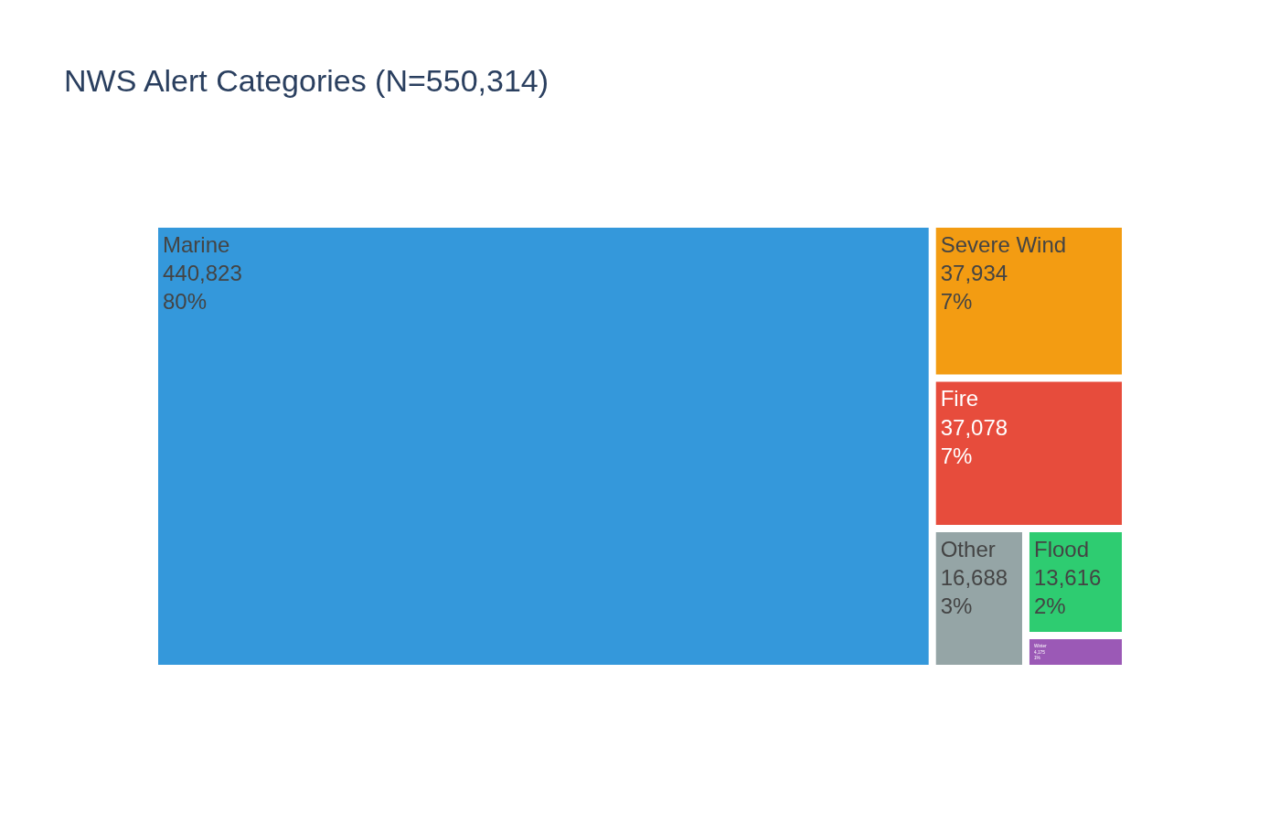
Baseline analysis of 550K NWS alerts (45 types, 8 days) + 69K historical tornado reports (1950-2023). 80% marine, 63x diurnal swing, May tornado peak, Kp cross-domain null. Foundation for dashboard and cross-domain work.

Visualization for NWS Severe Weather Baseline — Alert Patterns and Geographic Distribution
Interactive viz 7 data files
Space Weathercomplete
Mar 2026

X1.5 Solar Flare Watch — March 29, 2026

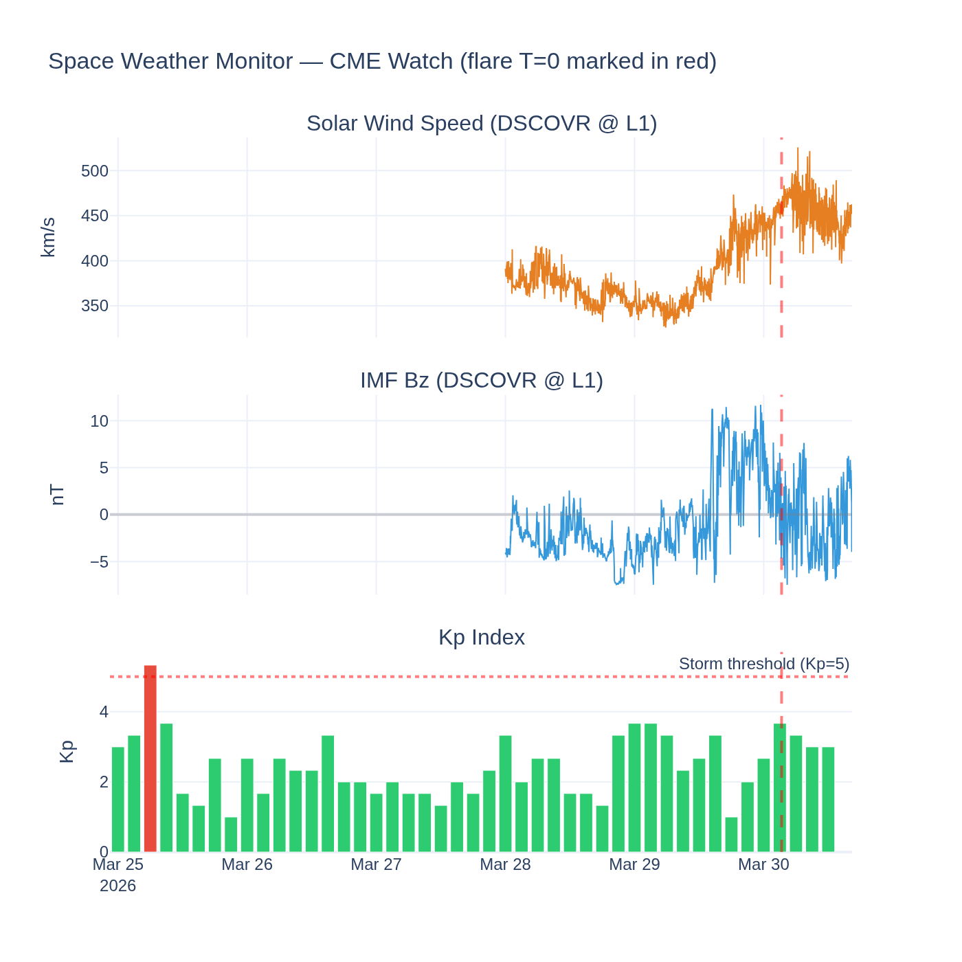
X1.5 flare (largest in 12.6M GOES readings) + 1,845 km/s CME. 6-entry lab notebook tracking the event over 60h. CME did not impact Earth. Successful infrastructure test of 7-stream monitoring pipeline.

Visualization for X1.5 Solar Flare Watch — March 29, 2026
Interactive viz 7 data files
Space Weatheraccepted
Mar 2026

LIGO/Virgo as accidental geophysical sensors — GW detector sensitivity vs space weather

Do geomagnetic storms degrade gravitational wave detector sensitivity? Can we turn LIGO/Virgo duty cycle data into an accidental geophysical measurement?

Visualization for LIGO/Virgo as accidental geophysical sensors — GW detector sensitivity vs space weather
Interactive viz 6 data files
Climatedraft
Mar 2026

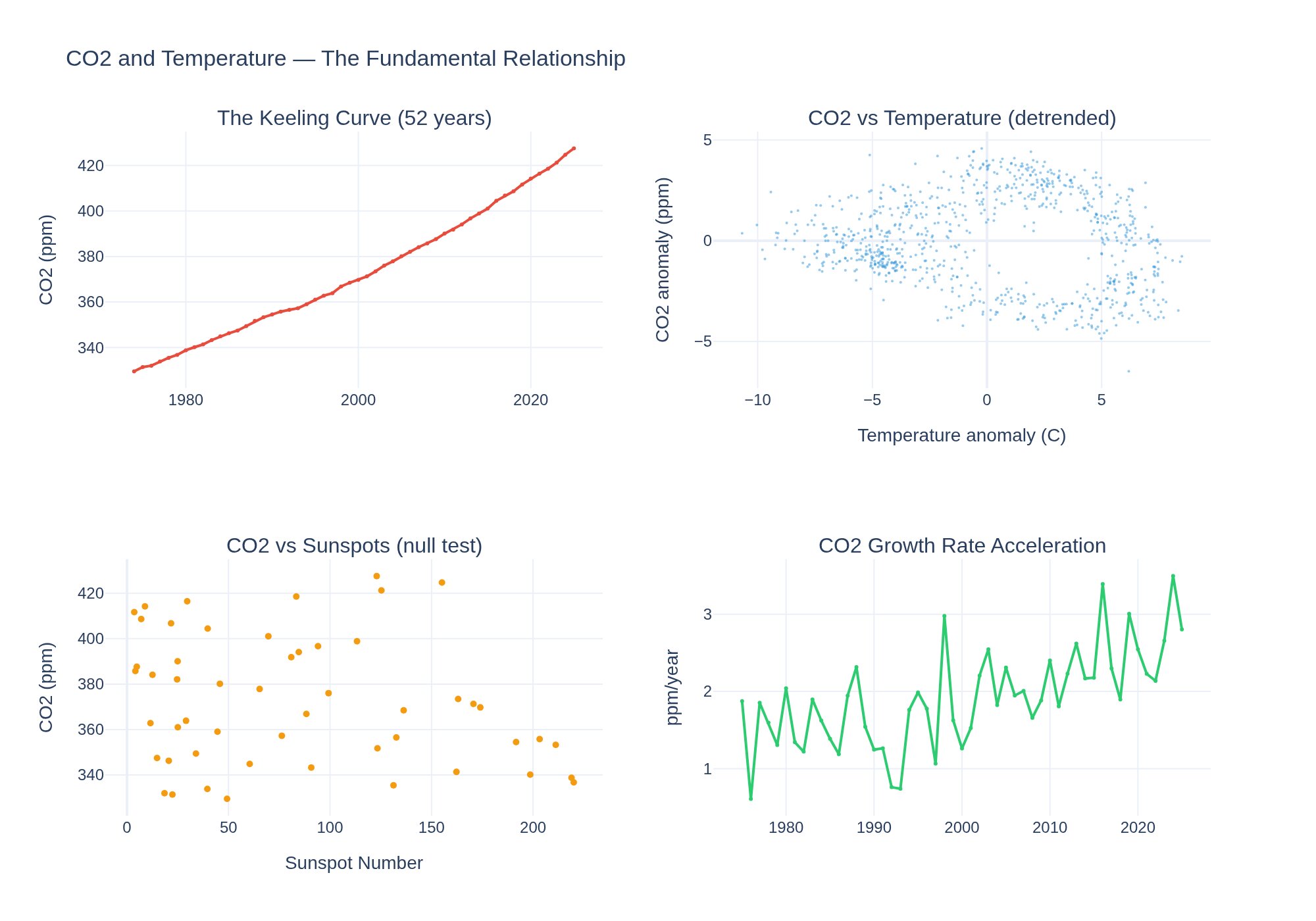
CO2 and Temperature Trend

Does the Keeling Curve predict temperature anomaly? 52yr CO2 vs temperature data.

Visualization for CO2 and Temperature Trend
Interactive viz 6 data files
Researchdraft
Mar 2026

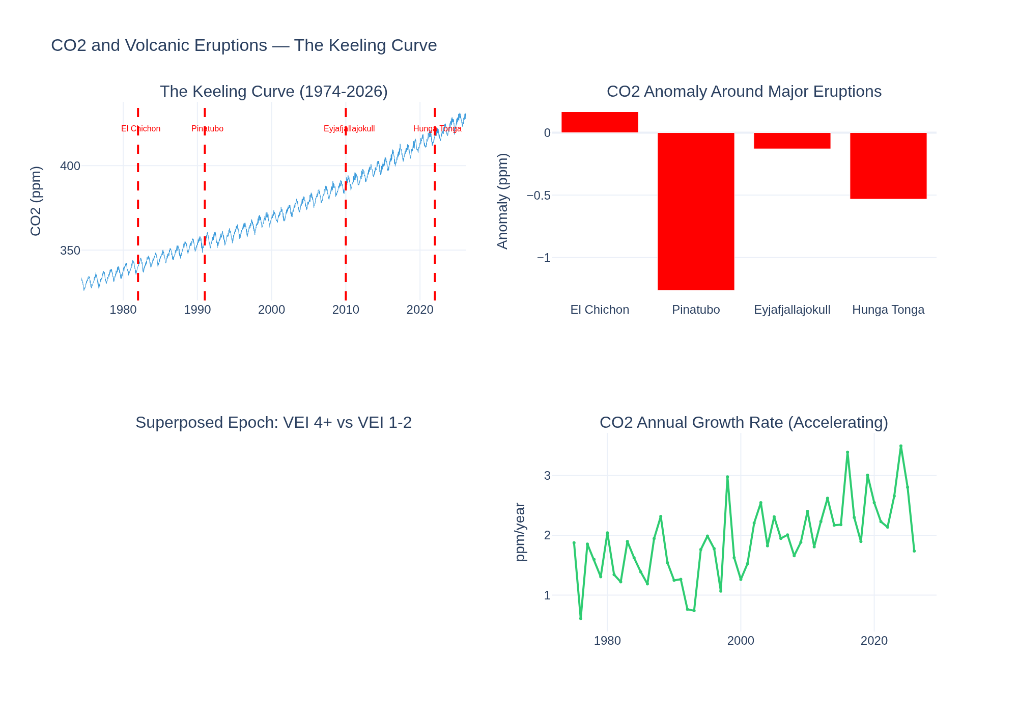
CO2 Seasonal Cycle and Volcanic Eruptions

Can we detect Pinatubo (1991), El Chichon (1982) in the Keeling Curve? Cross-reference CO2 with 5K eruption records.

Visualization for CO2 Seasonal Cycle and Volcanic Eruptions
Interactive viz 4 data files
Researchaccepted
Mar 2026

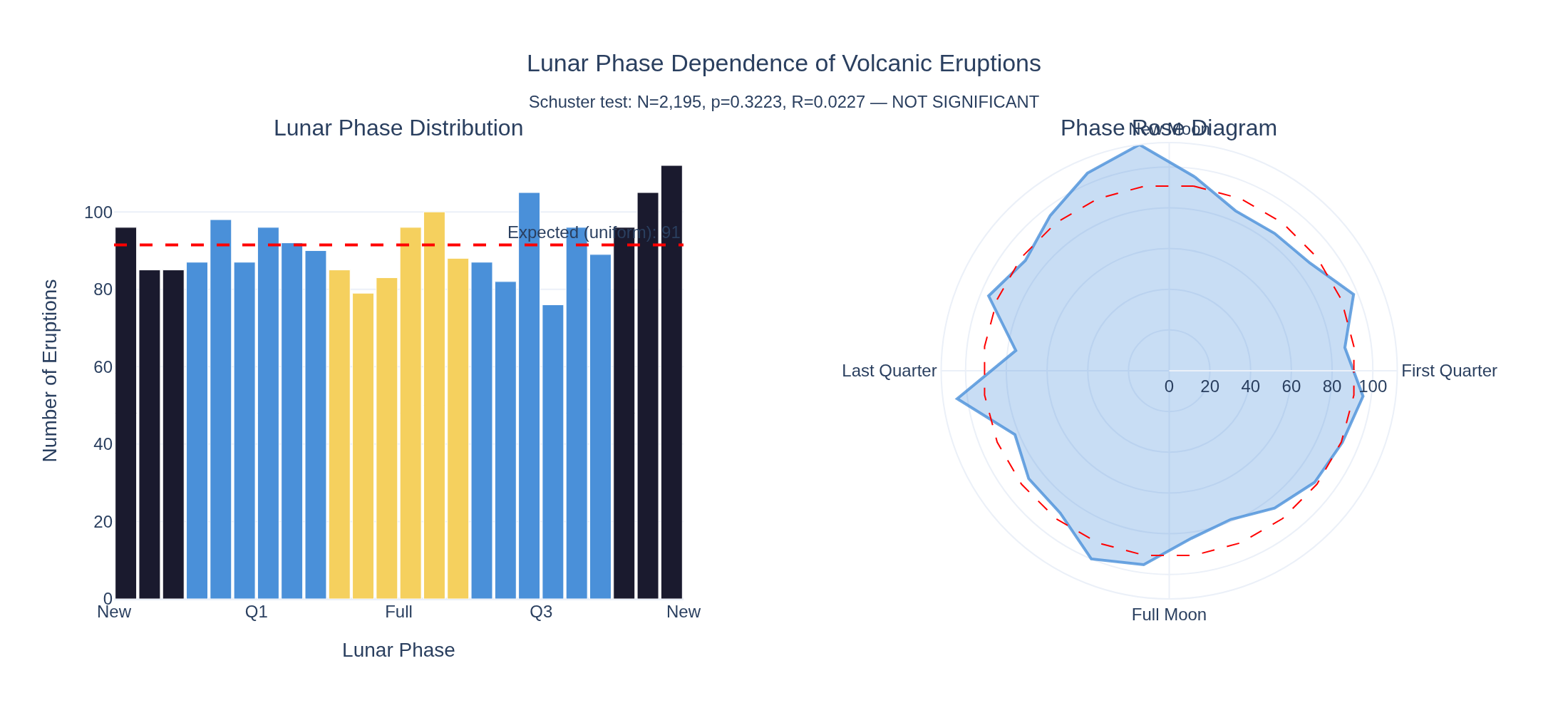
Tidal Forcing on Volcanic Eruptions

Schuster test: do volcanoes erupt at New/Full Moon?

Visualization for Tidal Forcing on Volcanic Eruptions
Interactive viz 2 data files
Seismologydraft
Mar 2026

Geomagnetic Storm Cascades

When Kp spikes, what else moves? Trace the cascade through AQI, earthquakes, tides, radiation, power systems, and atmospheric chemistry.

1 data files
Seismologydraft
Mar 2026

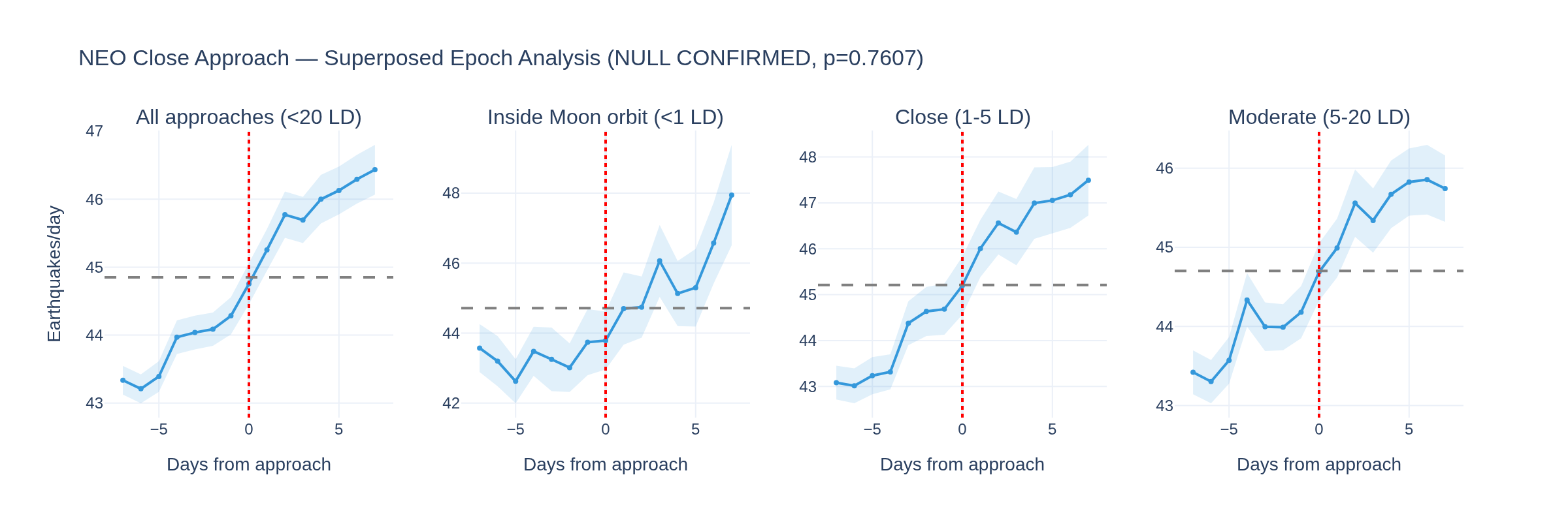
NEO Gravitational Null Test

Superposed epoch analysis: do near-Earth object close approaches produce detectable changes in earthquake rate, Kp, or tides?

Visualization for NEO Gravitational Null Test
Interactive viz 3 data files
Researchdraft
Mar 2026

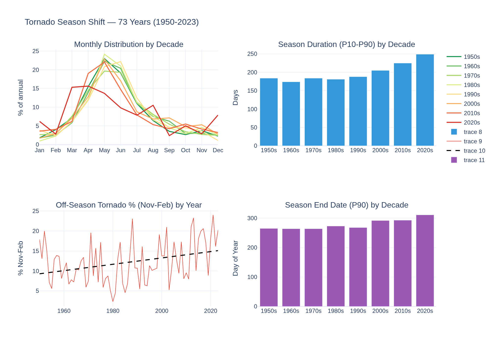
Tornado Season Shift Analysis

Is tornado season extending later into the year? 73 years of SPC data.

Visualization for Tornado Season Shift Analysis
Interactive viz 1 data files
Cross-Domaindraft
Mar 2026

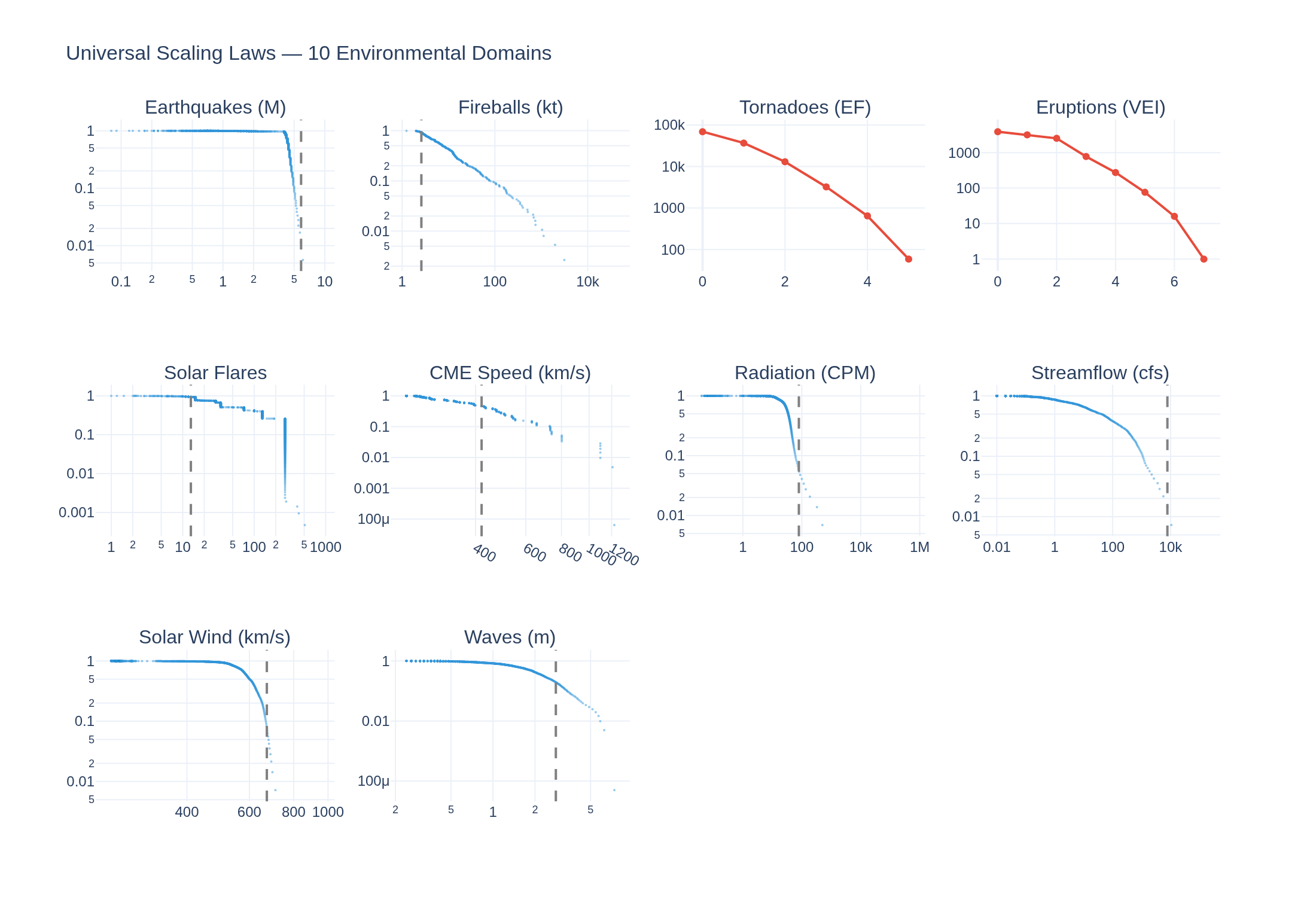
Universal Scaling Laws

Cross-domain distribution analysis: power law vs exponential vs lognormal vs Weibull across 10 environmental metrics

Visualization for Universal Scaling Laws
Interactive viz 2 data files
Seismologydraft
Mar 2026

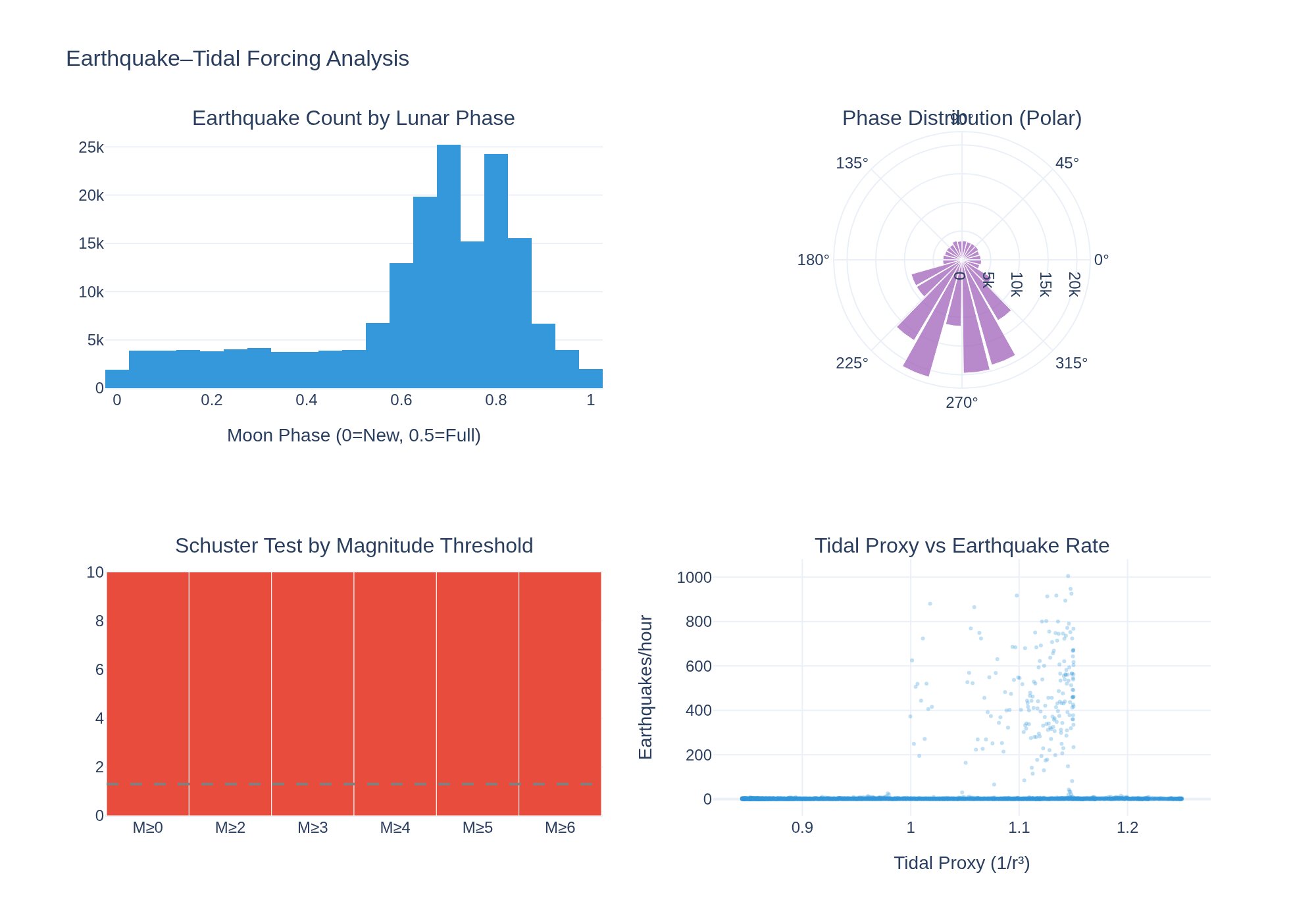
Earthquake–Tidal Forcing

Do earthquakes cluster at Full Moon, New Moon, or lunar perigee? Testing the 1-2% tidal triggering hypothesis with 172K earthquakes and 5K hours of JPL ephemeris.

Visualization for Earthquake–Tidal Forcing
Interactive viz 2 data files
Seismologydraft
Mar 2026

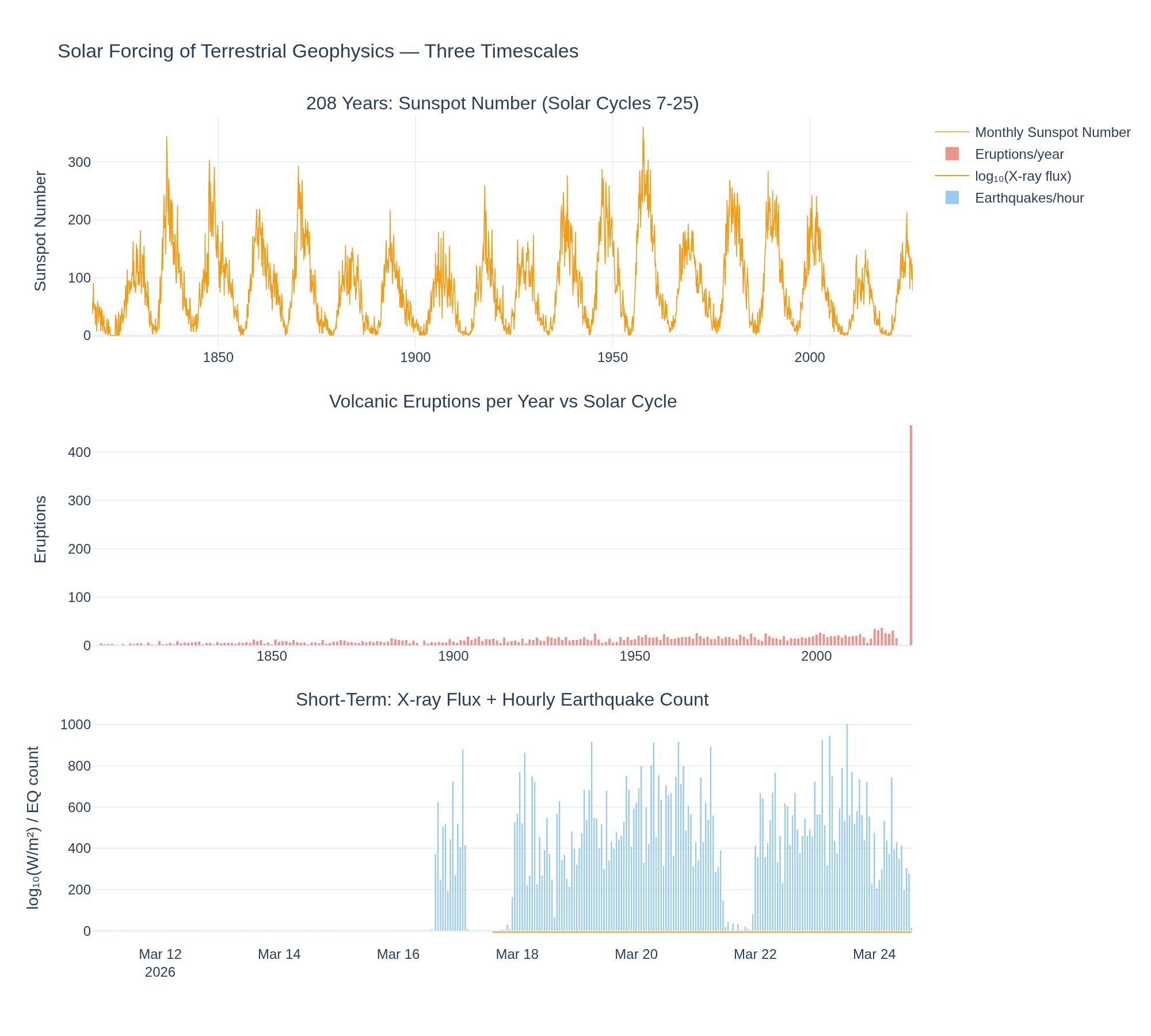
Solar Forcing of Terrestrial Geophysics

Do solar flares, CMEs, and the solar cycle directly drive earthquakes, volcanic eruptions, and severe weather? The definitive test.

Visualization for Solar Forcing of Terrestrial Geophysics
Interactive viz 11 data files
Seismologydraft
Mar 2026

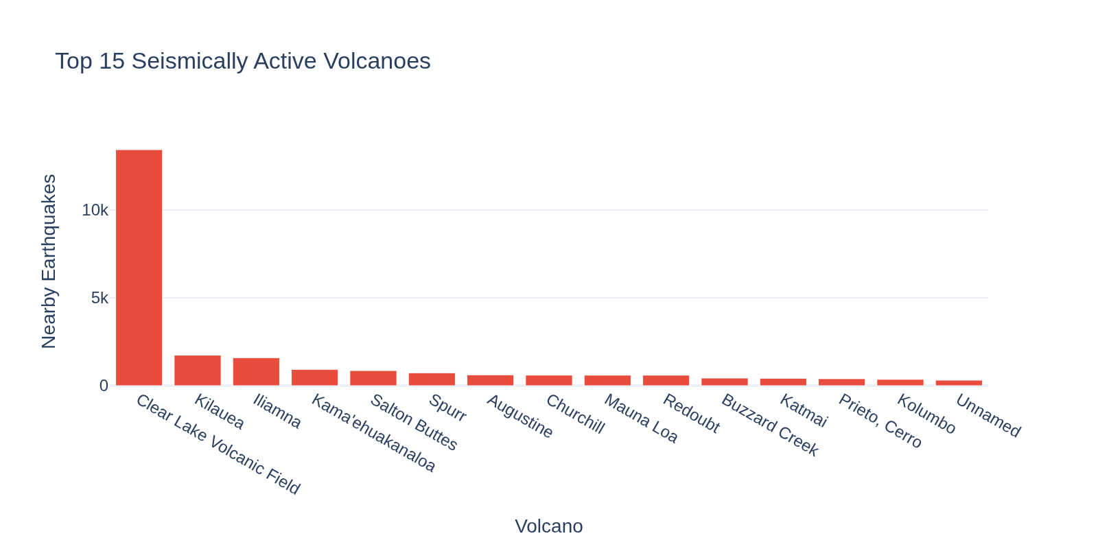
Volcano-Earthquake Coupling

Do earthquakes cluster near active volcanoes? Can seismic swarms predict eruptions?

Visualization for Volcano-Earthquake Coupling
Interactive viz 1 data files
Seismologydraft
Mar 2026

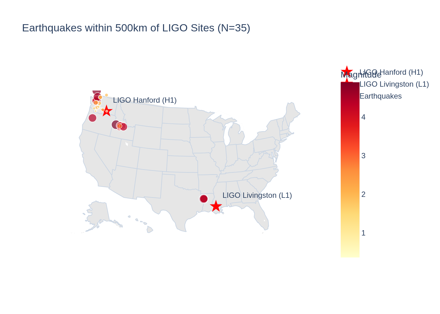
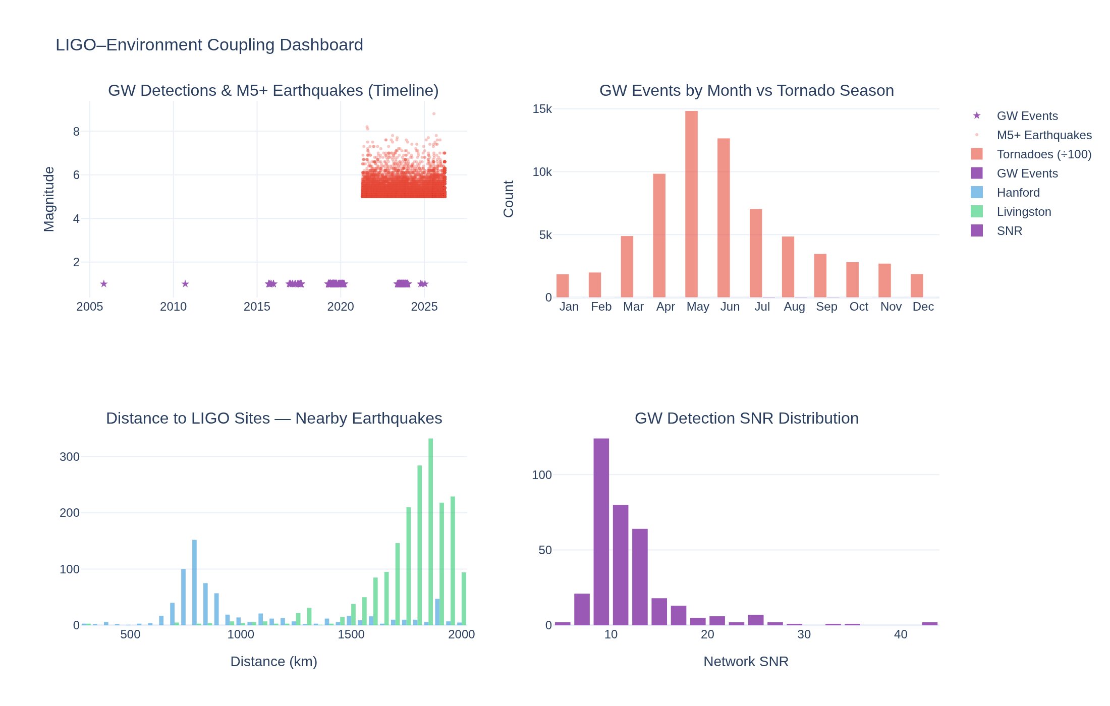
LIGO–Environment Coupling

Do earthquakes, ocean microseisms, and geomagnetic storms correlate with gravitational wave detector sensitivity?

Visualization for LIGO–Environment Coupling
Interactive viz 5 data files
Space Weatherdraft
Mar 2026

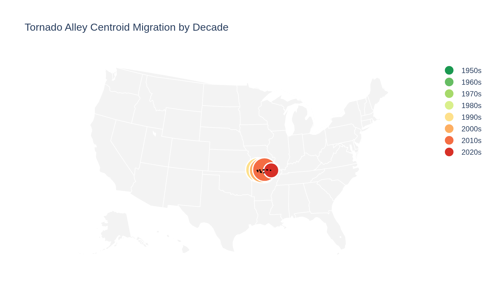
US Tornado Climatology 1950-2023

73-year analysis of tornado patterns, Tornado Alley migration, EF trends, and solar-tornado coupling

Visualization for US Tornado Climatology 1950-2023
Interactive viz 4 data files
Climatedraft
Mar 2026

Air Quality–Weather Coupling

Test whether temperature patterns predict PM2.5 spikes via inversion-like conditions

Visualization for Air Quality–Weather Coupling
Interactive viz 3 data files
Cross-Domaindraft
Mar 2026

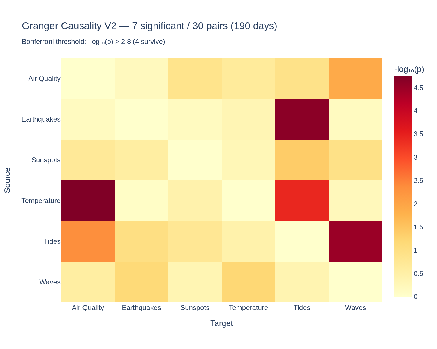
Cross-Domain Granger Causality Network

Test which environmental signals Granger-cause others — the big connectivity map

Visualization for Cross-Domain Granger Causality Network
Interactive viz 5 data files
Hydrologydraft
Mar 2026

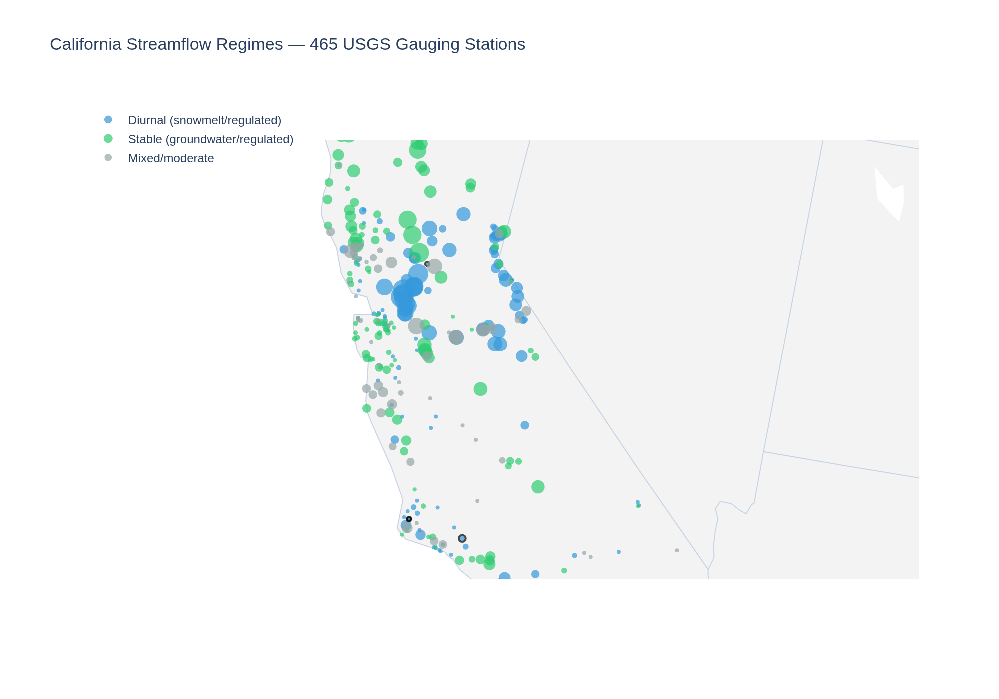
California Streamflow Anomaly Detection

Detect anomalous streamflow patterns across 472 USGS California gauging stations

Visualization for California Streamflow Anomaly Detection
Interactive viz 3 data files
Climatedraft
Mar 2026

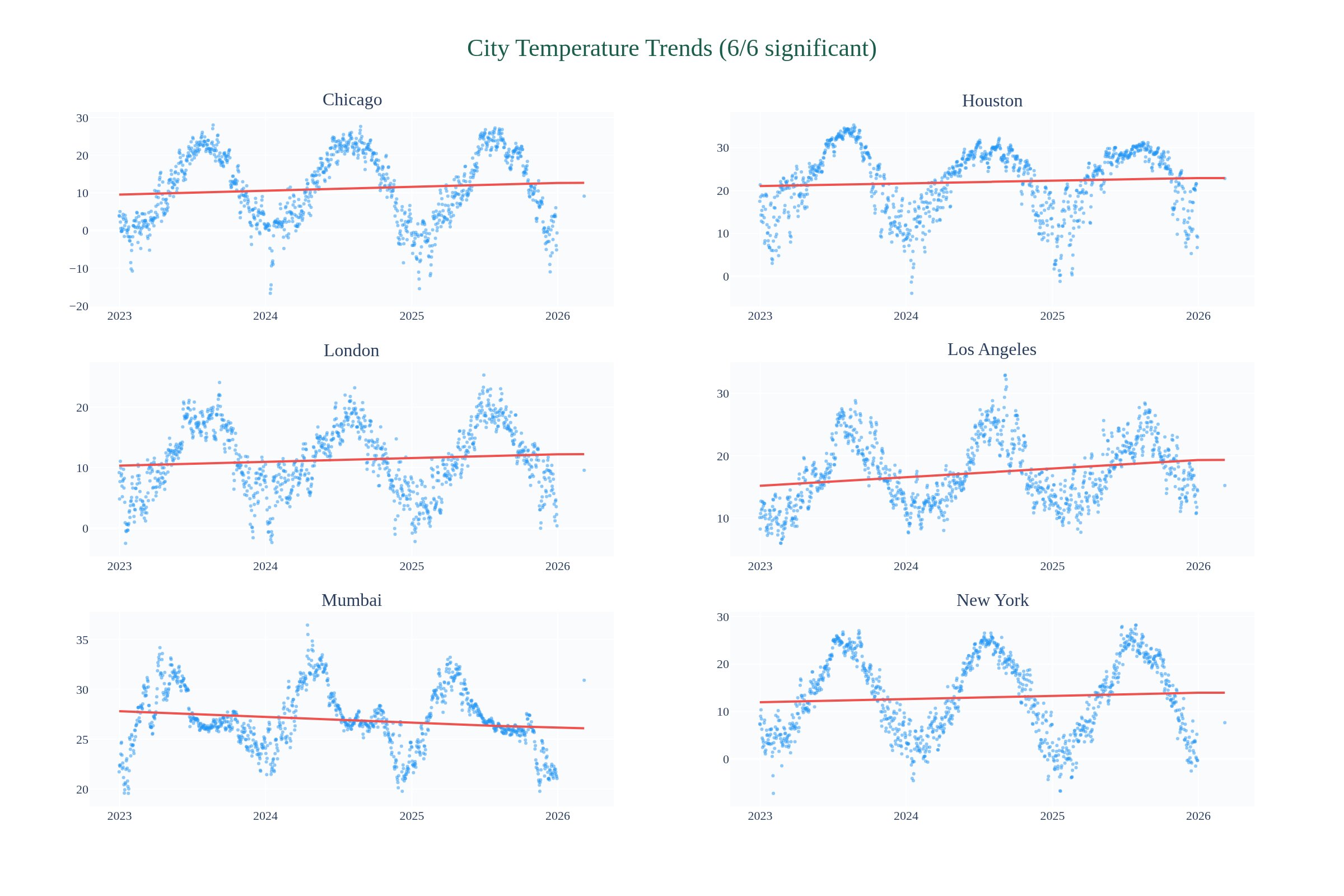
Urban Temperature Trends — Are Cities Warming in Real-Time Data?

Testing whether 3 years of NASA POWER daily temperature data (10 cities) shows detectable warming trends. Using linear regression, seasonal decomposition, and anomaly scoring.

Visualization for Urban Temperature Trends — Are Cities Warming in Real-Time Data?
Interactive viz 2 data files
Space Weatherdraft
Mar 2026

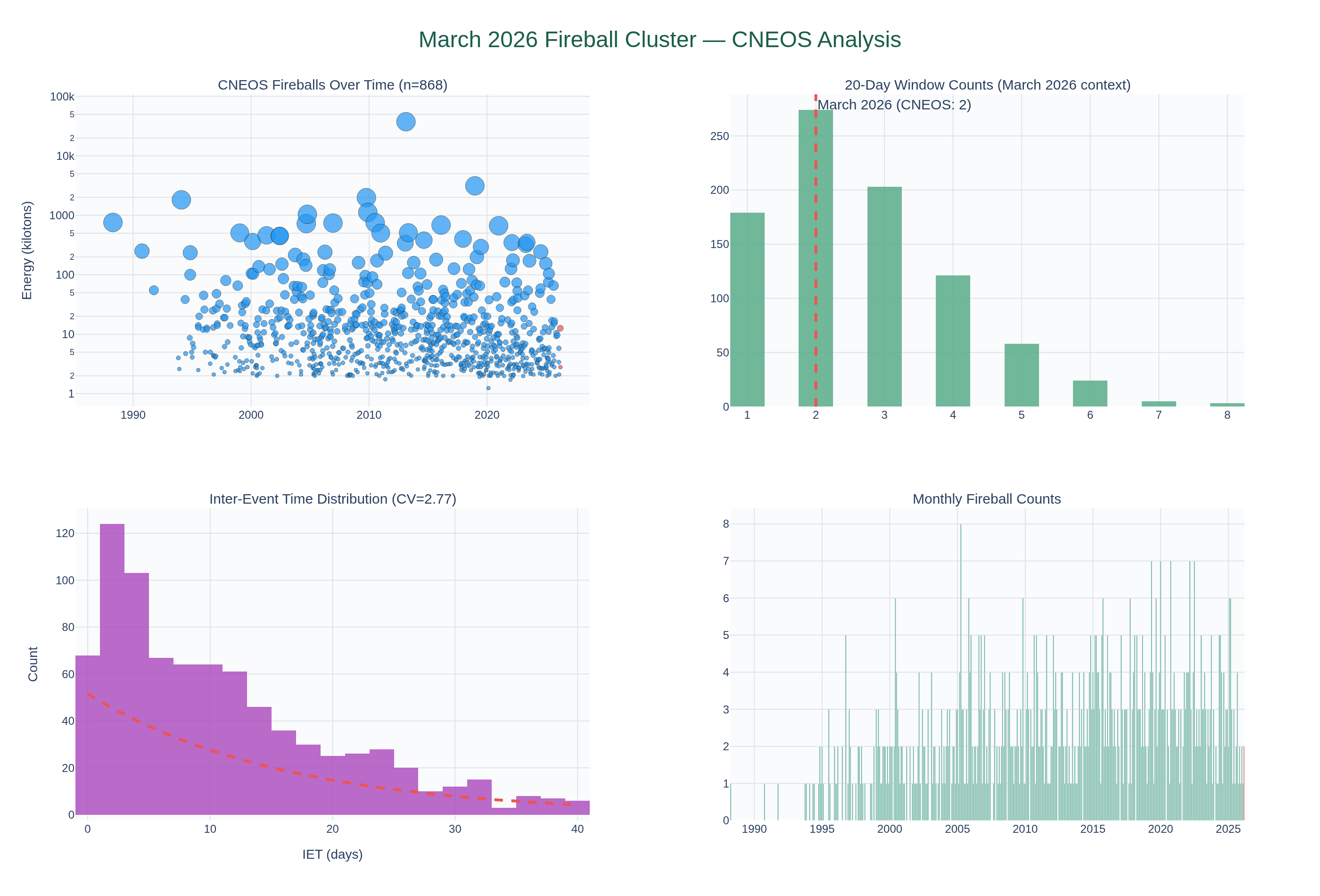
March 2026 Fireball Cluster — Statistical Significance and Space Weather Context

Testing whether the March 2026 fireball cluster (11 events in 20 days, 3 meteorite falls) is statistically significant against the CNEOS historical baseline. Cross-correlating with TerraPulse space weather data to test solar activity connection.

Visualization for March 2026 Fireball Cluster — Statistical Significance and Space Weather Context
Interactive viz 8 data files
Radiationdraft
Mar 2026

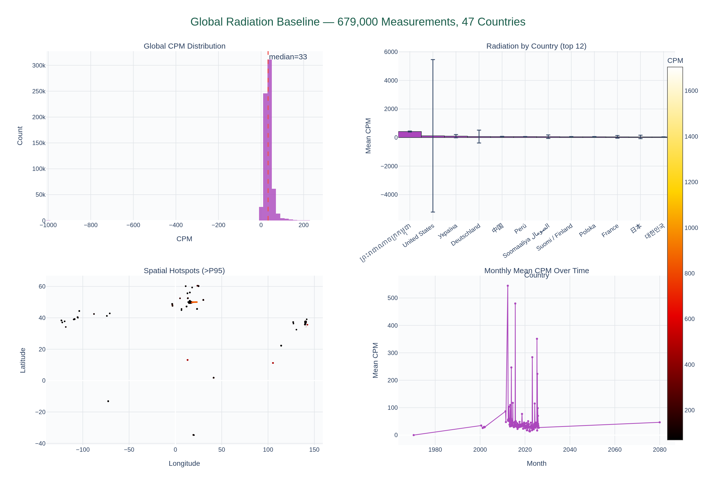
Global Environmental Radiation Baseline from Citizen Science — Signal vs Sampling Bias

Separating physical radiation patterns from observational campaign clustering in 679K Safecast measurements across 45 countries. Can citizen science data establish a reliable global radiation baseline?

Visualization for Global Environmental Radiation Baseline from Citizen Science — Signal vs Sampling Bias
Interactive viz 2 data files
Seismologydraft
Mar 2026

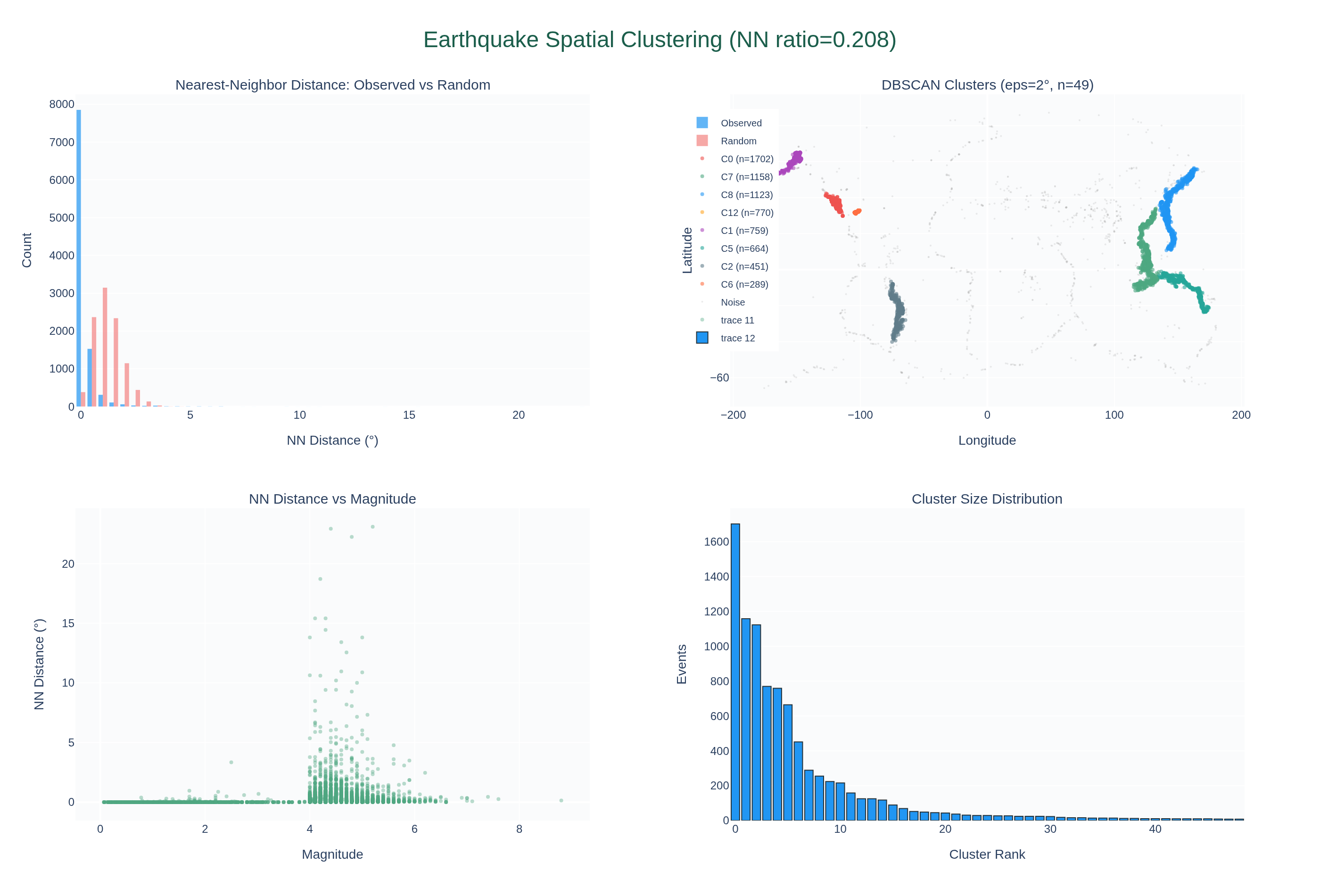
Temporal Clustering of Global M4+ Earthquakes — Spatial clustering

Derivative study expanding on: Spatial clustering. nearest-neighbor distance analysis Parent study: Temporal Clustering of Global M4+ Earthquakes (earthquake-temporal-clustering)

Visualization for Temporal Clustering of Global M4+ Earthquakes — Spatial clustering
Interactive viz 4 data files
Cross-Domaindraft
Mar 2026

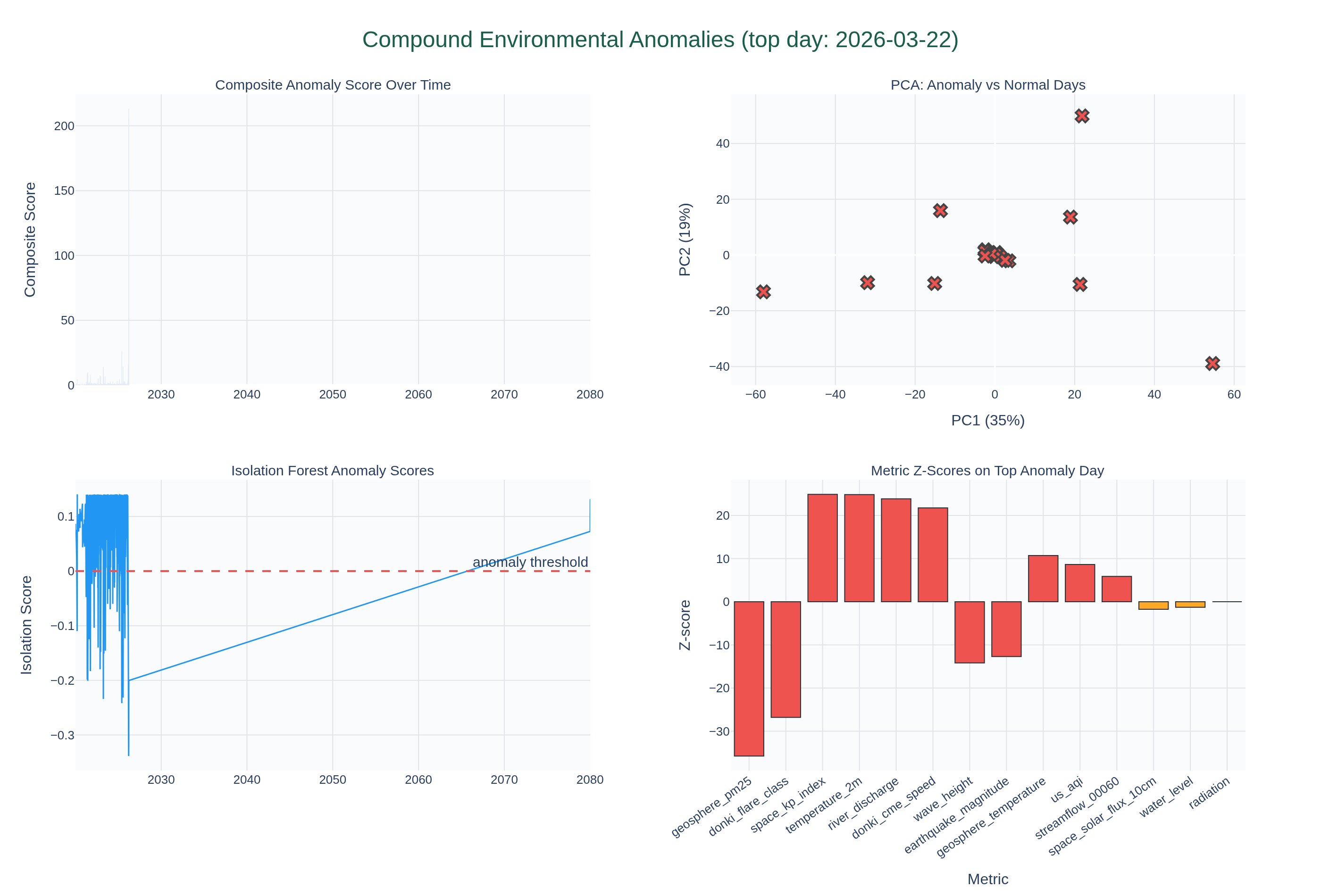
Compound Environmental Anomalies — Multi-Metric Unusual Days

Detecting days where multiple environmental metrics are simultaneously anomalous using Z-score analysis and Isolation Forest. When earthquakes, space weather, and air quality all spike together — is it coincidence or connection?

Visualization for Compound Environmental Anomalies — Multi-Metric Unusual Days
Interactive viz 2 data files
Cross-Domainpaper
Mar 2026

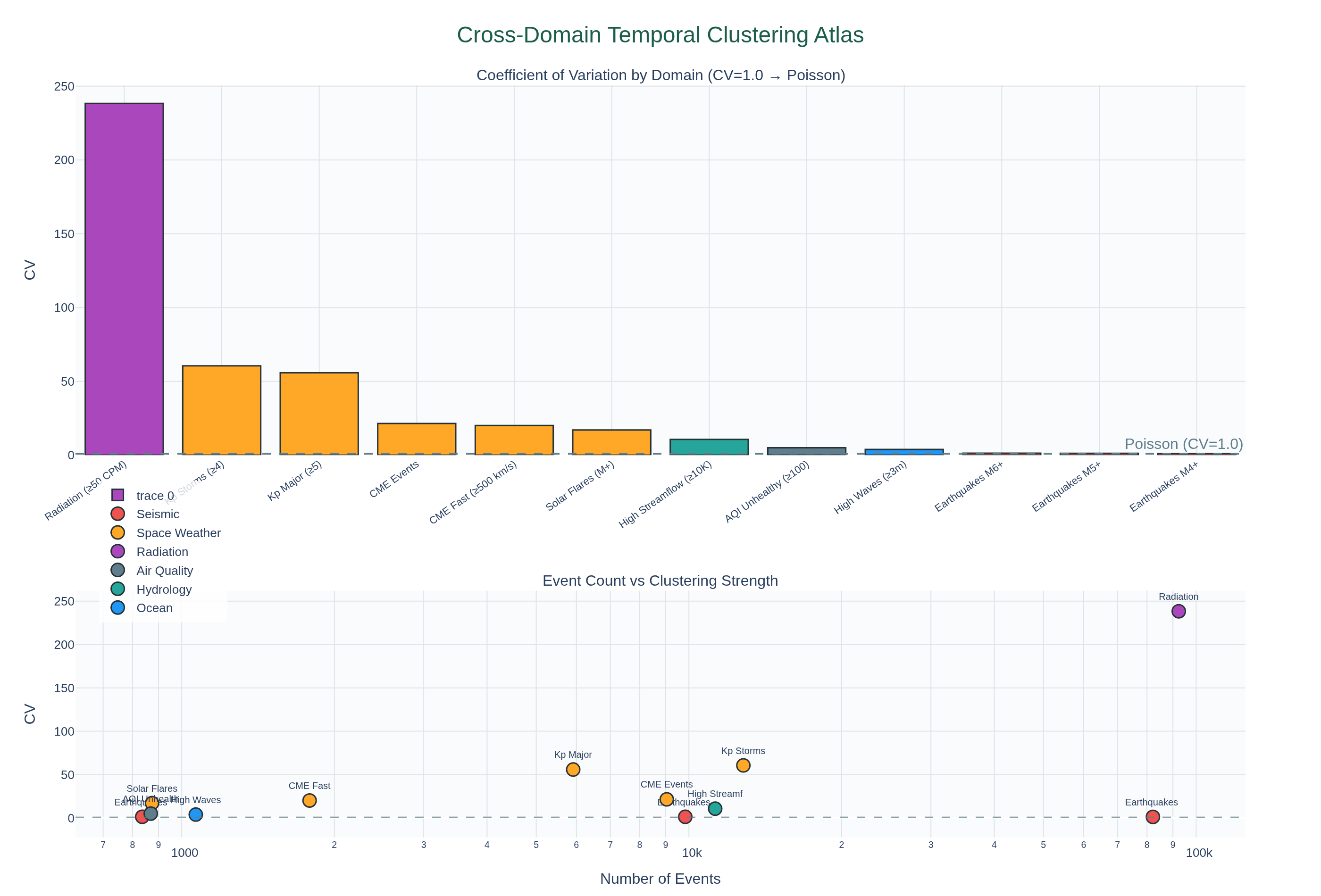
Cross-Domain Temporal Clustering Atlas — Inter-Event Time Analysis Across Environmental Metrics

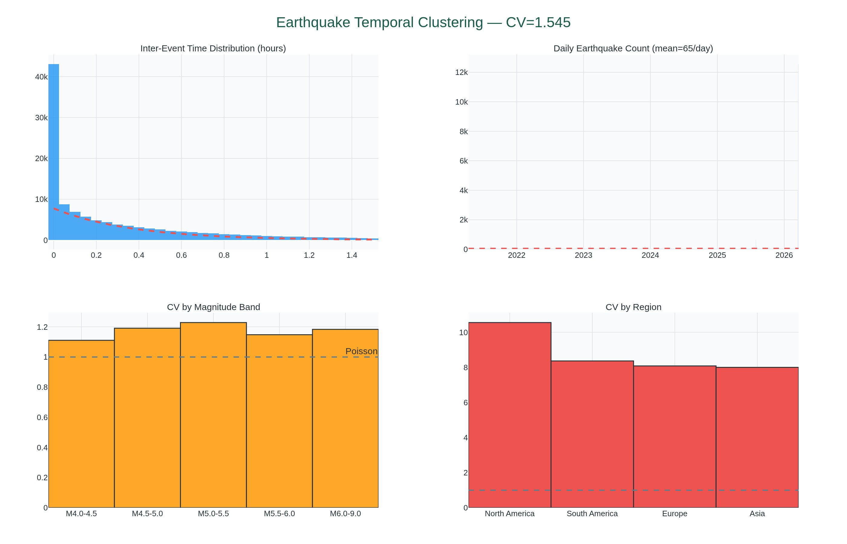
Applying the coefficient of variation (CV) inter-event time method proven on earthquakes (CV=1.545) to CMEs, radiation spikes, geomagnetic storms, AQI exceedances, and flood events. Building a clustering atlas across domains.

Visualization for Cross-Domain Temporal Clustering Atlas — Inter-Event Time Analysis Across Environmental Metrics
Key finding12/12 clustered
Earthquakes M4+
CV=1.17 · 82,189 events
mildly clustered
Earthquakes M5+
CV=1.3 · 9,836 events
mildly clustered
Earthquakes M6+
CV=1.32 · 836 events
CLUSTERED
Kp Storms (≥4)
CV=60.58 · 12,804 events
CLUSTERED
Kp Major (≥5)
CV=55.81 · 5,914 events
CLUSTERED
CME Events
CV=21.49 · 9,043 events
CLUSTERED
Read PDF Interactive viz 13 data files
Space Weatherdraft
Mar 2026

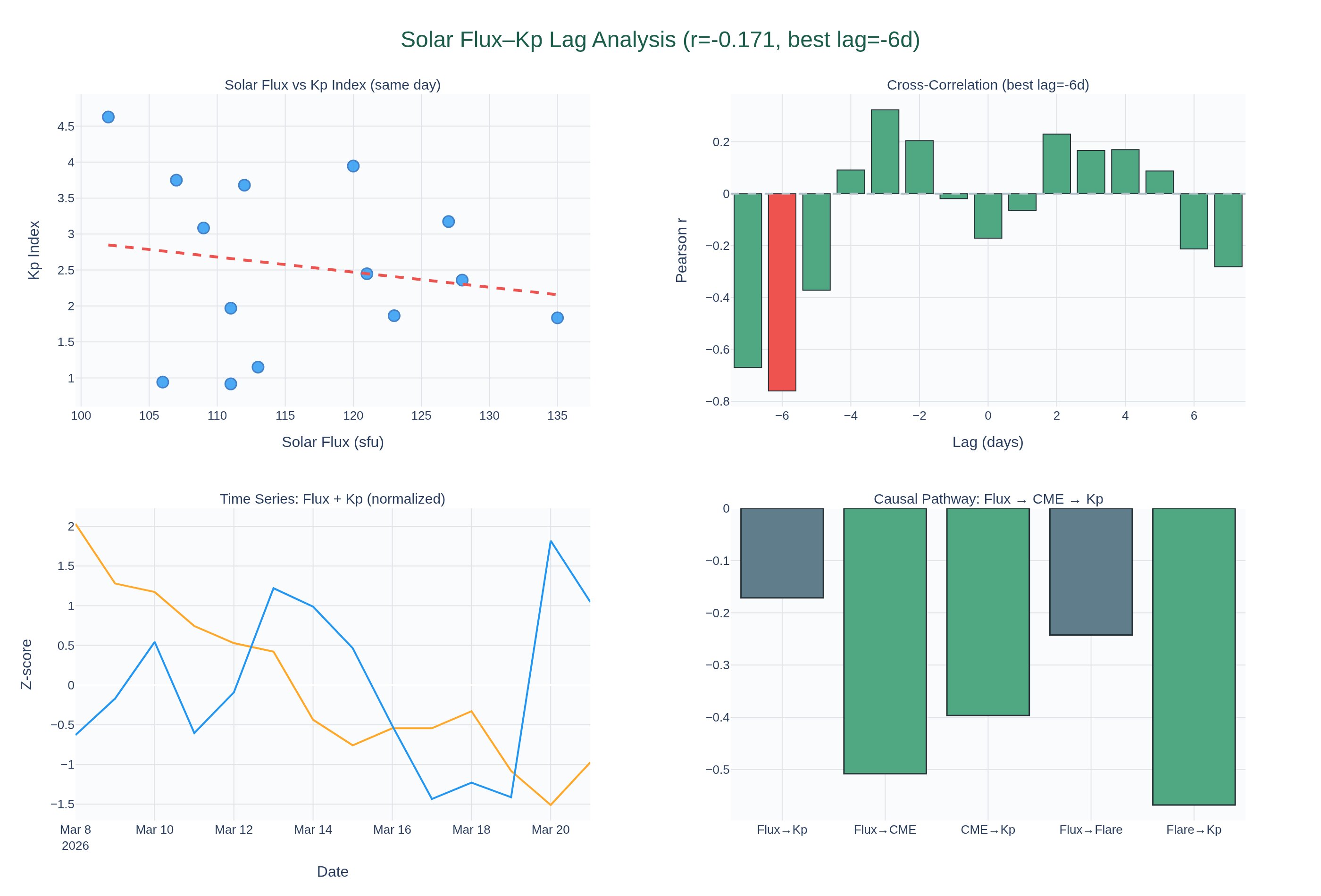
Solar Flux–Kp Index Time Lag — Paper Replication Study

Replicating Georgieva & Kirov (2010) claim that the correlation between solar activity and geomagnetic activity varies with a changing time lag. Testing with NOAA SWPC solar flux and Kp index data.

Visualization for Solar Flux–Kp Index Time Lag — Paper Replication Study
Interactive viz 5 data files
Seismologydraft
Mar 2026

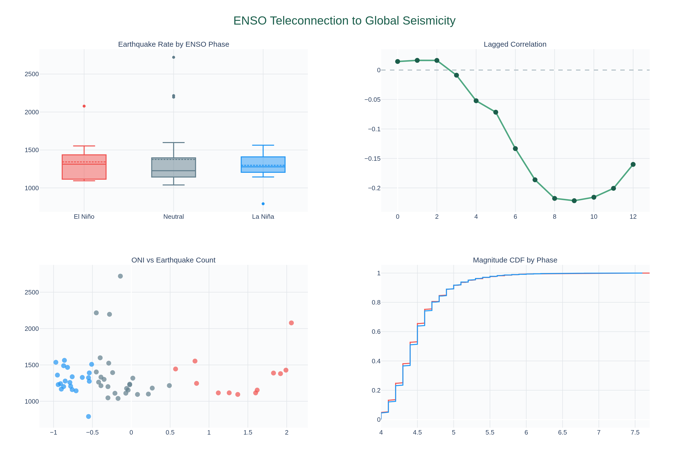
ENSO Teleconnection to Global Seismicity — Replication Study

Replicating and extending published claims that El Niño/La Niña phases modulate global earthquake rates. Testing crustal loading hypothesis via sea level redistribution. Using 76 years of ONI data and 5 years of USGS M4+ earthquake records.

Visualization for ENSO Teleconnection to Global Seismicity — Replication Study
Interactive viz 8 data files
4 reference papers
Seismologydraft
Mar 2026

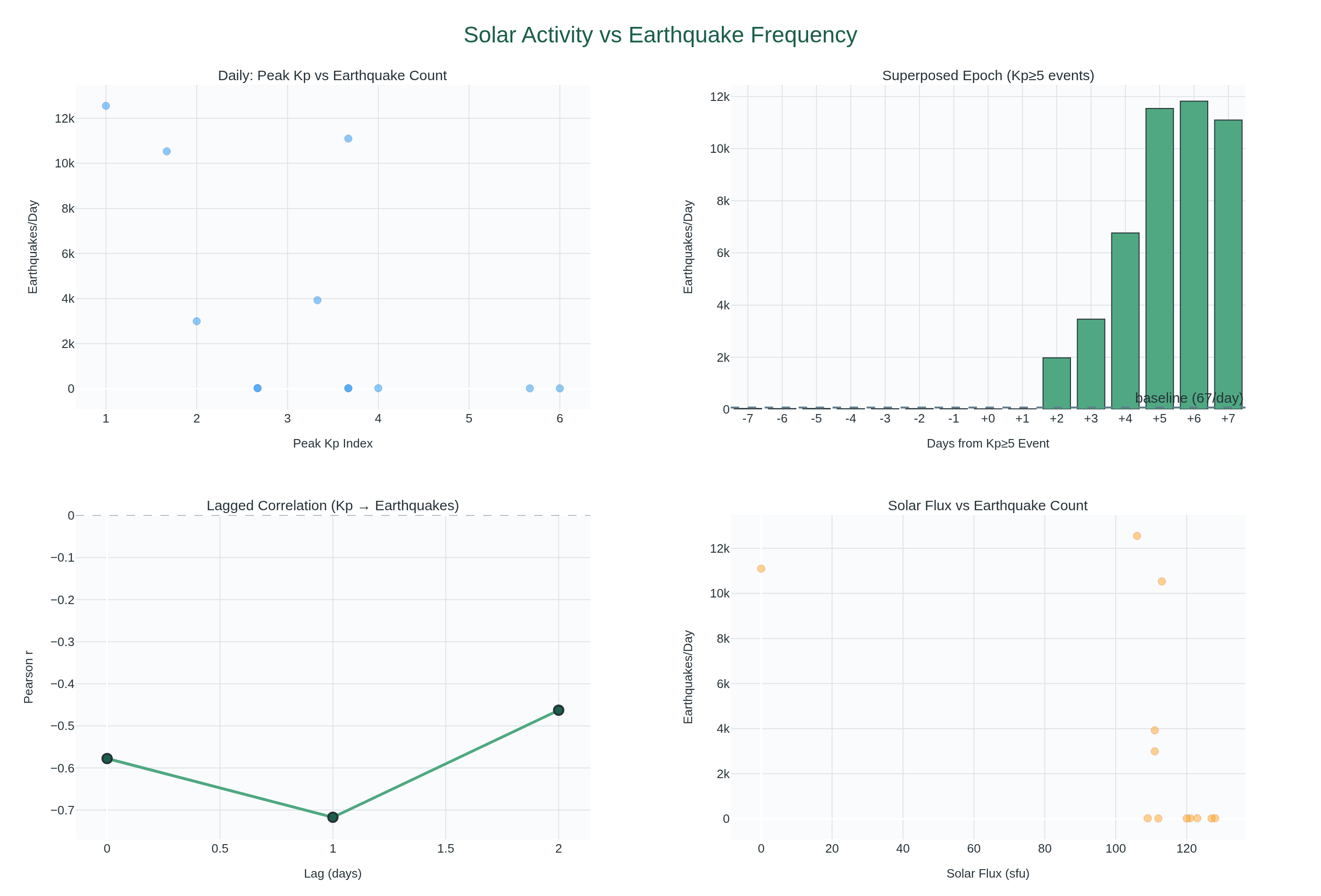
Solar Activity and Earthquake Frequency — Is There a Signal?

Testing the controversial hypothesis that solar activity (CMEs, solar flux, geomagnetic storms) correlates with earthquake frequency or magnitude. Using NOAA SWPC, NASA DONKI, and USGS earthquake data.

Visualization for Solar Activity and Earthquake Frequency — Is There a Signal?
Interactive viz 8 data files
4 reference papers
Seismologydraft
Mar 2026

Temporal Clustering of Global M4+ Earthquakes

Analyzing whether significant earthquakes cluster in time beyond what random (Poisson) occurrence would predict. Testing the hypothesis of earthquake triggering — does one large quake increase the probability of subsequent events?

Visualization for Temporal Clustering of Global M4+ Earthquakes
Interactive viz 3 data files
Climatedraft
Mar 2026

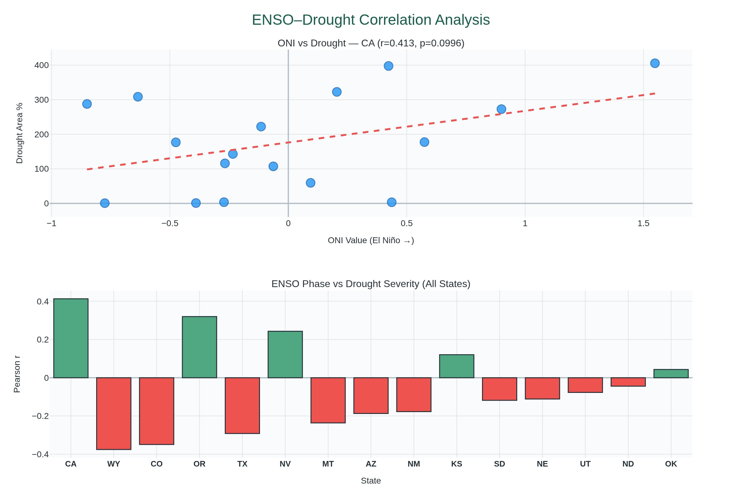
ENSO Phase vs US Drought Severity

Investigating whether El Niño/La Niña phases predict drought severity in US states. Using 76 years of ONI data and 16 years of USDM drought records.

Visualization for ENSO Phase vs US Drought Severity
Interactive viz 4 data files